Sangmélima geodata
Sangmélima (South) is a populated place; located in Cameroon in Africa/Douala (GMT+1) time zone. With population of 54,251 people, there are 32 cities with bigger population in this country. Compared to other cities in Cameroon, 96.7% of cities are located further ↑North; 67.2% of cities are located further ←West and 58.2% of cities have lower elevation than Sangmélima. Note1


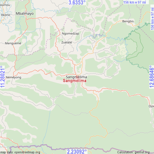
Sangmélima GPS coordinates[2]
2° 55' 59.988" North, 11° 58' 59.988" East
| Map corner | latitude | longitude |
|---|---|---|
| Upper-left | 3.6353°, | 11.28021° |
| Center: | 2.93333°, | 11.98333° |
| Lower-right: | 2.23092°, | 12.68646° |
| Map W x H: | 156.2×156.2 km | = 97.1×97.1mi |
| max Lat: | 12.57535° ⇑96.7% North |
| Sangmélima: | 2.93333° |
| min Lat: | ⇓3.3% South 2.35° |
| min Long | Sangmélima | max Long |
| 8.8724° | 11.98333° | 15.23288° |
| W 67.2%⇐ | ⇒32.8% E |
Elevation
Elevation of Sangmélima is 675 m = 2215 ft, and this is 1.1 m = 4 ft above average elevation for this country.
| Max E: |
1687 m = 5535 ft | 41.8% |
| Sangmélima | 675 m 2215 ft | |
| Avg. | 673.9 m = 2211 ft | |
Min E: |
1 m = 3 ft | 58.2% |
See also: Sangmélima elevation on elevation.city.
Geographical zone
Sangmélima is located in North Torrid zone (between Equator and Tropic of Cancer). Distance of Equator is 326.2 km =202.7 mi to South.| Distance of | km | miles | from Sangmélima |
|---|---|---|---|
| North Pole | 9680.9 | 6015.4 | to North |
| Arctic Circle | 7075 | 4396.2 | to North |
| Tropic Cancer | 2279.8 | 1416.6 | to North |
| Equator | 326.2 | 202.7 | to South |


Nearby cities:
15 places around Sangmélima: (largest is in red/bold)
• Akono
95.8 km =59.5 mi,  311°
311°
• Akonolinga
97.3 km =60.5 mi,  17°
17°
• Ambam
98.9 km =61.5 mi,  231°
231°
• Essé
130.1 km =80.8 mi,  355°
355°
• Lolodorf
142.7 km =88.7 mi,  283°
283°
• Mbalmayo
84.2 km =52.3 mi,  320°
320°
• Mbankomo
115.6 km =71.8 mi, 324°
• Mvangué
52 km =32.3 mi,  274°
274°
• Ngomedzap
93.8 km =58.3 mi,  292°
292°
• Obala
145.9 km =90.7 mi,  339°
339°
• Okoa
124.3 km =77.2 mi, 339°
• Okola
137.6 km =85.5 mi,  331°
331°
• Yaoundé
116 km =72.1 mi, 333°
• Ébolowa
92.6 km =57.5 mi, 267°
• Évodoula
154.6 km =96.1 mi, 325°
Sources, notices
• [Note1] Compared only with cities in Cameroon existing in our database
• [Src1] Map data: © OpenStreetMap contributors (CC-BY-SA)
• [Src2] Other city data from geonames.org with taken over terms of usage.
• [Src3] Geographical zone / Annual Mean Temperature by Robert A. Rohde @ Wikipedia
