Lolodorf geodata
Lolodorf (South) is a populated place; located in Cameroon in Africa/Douala (GMT+1) time zone. With population of 22,252 people, there are 56 cities with bigger population in this country. Compared to other cities in Cameroon, 94.3% of cities are located further ↑North; 54.1% of cities are located further →East and 67.2% of cities have higher elevation than Lolodorf. Note1


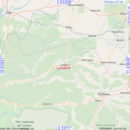
Lolodorf GPS coordinates[2]
3° 13' 59.988" North, 10° 43' 59.988" East
| Map corner | latitude | longitude |
|---|---|---|
| Upper-left | 3.93508°, | 10.03021° |
| Center: | 3.23333°, | 10.73333° |
| Lower-right: | 2.5311°, | 11.43646° |
| Map W x H: | 156.1×156.1 km | = 97×97mi |
| max Lat: | 12.57535° ⇑94.3% North |
| Lolodorf: | 3.23333° |
| min Lat: | ⇓5.7% South 2.35° |
| min Long | Lolodorf | max Long |
| 8.8724° | 10.73333° | 15.23288° |
| W 45.9%⇐ | ⇒54.1% E |
Elevation
Elevation of Lolodorf is 467 m = 1532 ft, and this is 206.9 m = 679 ft below average elevation for this country.
| Max E: |
1687 m = 5535 ft | 67.2% |
| Avg. | 673.9 m = 2211 ft | |
| Lolodorf | 467 m = 1532 ft | |
Min E: |
1 m = 3 ft | 32.8% |
See also: Cameroon elevation on elevation.city.
Geographical zone
Lolodorf is located in North Torrid zone (between Equator and Tropic of Cancer). Distance of Equator is 359.5 km =223.4 mi to South.| Distance of | km | miles | from Lolodorf |
|---|---|---|---|
| North Pole | 9647.5 | 5994.7 | to North |
| Arctic Circle | 7041.7 | 4375.5 | to North |
| Tropic Cancer | 2246.4 | 1395.8 | to North |
| Equator | 359.5 | 223.4 | to South |


Nearby cities:
15 places around Lolodorf: (largest is in red/bold)
• Akom II
53.3 km =33.1 mi,  200°
200°
• Akono
72.9 km =45.3 mi,  66°
66°
• Dizangué
102.2 km =63.5 mi,  305°
305°
• Edéa
91.7 km =57 mi, 313°
• Eséka
46.5 km =28.9 mi,  4°
4°
• Kribi
97.4 km =60.5 mi,  250°
250°
• Maan
99.1 km =61.6 mi,  187°
187°
• Mbalmayo
90.7 km =56.4 mi, 69°
• Mbankomo
94.6 km =58.8 mi,  49°
49°
• Mvangué
91.9 km =57.1 mi,  108°
108°
• Ngambé
112 km =69.6 mi,  353°
353°
• Ngomedzap
51.8 km =32.2 mi,  87°
87°
• Yaoundé
111.9 km =69.5 mi, 50°
• Ébolowa
59.3 km =36.8 mi,  128°
128°
• Évodoula
107.8 km =67 mi,  28°
28°
Sources, notices
• [Note1] Compared only with cities in Cameroon existing in our database
• [Src1] Map data: © OpenStreetMap contributors (CC-BY-SA)
• [Src2] Other city data from geonames.org with taken over terms of usage.
• [Src3] Geographical zone / Annual Mean Temperature by Robert A. Rohde @ Wikipedia
