Akom II geodata
Akom II (South) is a populated place; located in Cameroon in Africa/Douala (GMT+1) time zone. With population of 9,709 people, there are 73 cities with bigger population in this country. Compared to other cities in Cameroon, 98.4% of cities are located further ↑North; 59.8% of cities are located further →East and 63.1% of cities have higher elevation than Akom II. Note1


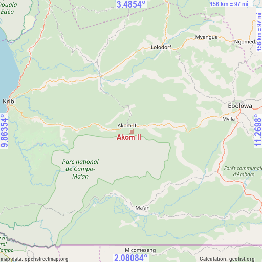
Akom II GPS coordinates[2]
2° 46' 59.988" North, 10° 34' 0.012" East
| Map corner | latitude | longitude |
|---|---|---|
| Upper-left | 3.4854°, | 9.86354° |
| Center: | 2.78333°, | 10.56667° |
| Lower-right: | 2.08084°, | 11.2698° |
| Map W x H: | 156.2×156.2 km | = 97.1×97.1mi |
| max Lat: | 12.57535° ⇑98.4% North |
| Akom II: | 2.78333° |
| min Lat: | ⇓1.6% South 2.35° |
| min Long | Akom II | max Long |
| 8.8724° | 10.56667° | 15.23288° |
| W 40.2%⇐ | ⇒59.8% E |
Elevation
Elevation of Akom II is 507 m = 1663 ft, and this is 166.9 m = 548 ft below average elevation for this country.
| Max E: |
1687 m = 5535 ft | 63.1% |
| Avg. | 673.9 m = 2211 ft | |
| Akom II | 507 m = 1663 ft | |
Min E: |
1 m = 3 ft | 36.9% |
See also: Cameroon elevation on elevation.city.
Geographical zone
Akom II is located in North Torrid zone (between Equator and Tropic of Cancer). Distance of Equator is 309.5 km =192.3 mi to South.| Distance of | km | miles | from Akom II |
|---|---|---|---|
| North Pole | 9697.6 | 6025.8 | to North |
| Arctic Circle | 7091.7 | 4406.6 | to North |
| Tropic Cancer | 2296.4 | 1426.9 | to North |
| Equator | 309.5 | 192.3 | to South |


Nearby cities:
15 places around Akom II: (largest is in red/bold)
• Akono
116.6 km =72.5 mi,  46°
46°
• Ambam
91.2 km =56.7 mi,  119°
119°
• Dizangué
127.1 km =79 mi,  329°
329°
• Edéa
122.9 km =76.4 mi,  336°
336°
• Eséka
98.9 km =61.5 mi,  12°
12°
• Kribi
75.2 km =46.7 mi,  283°
283°
• Lolodorf
53.3 km =33.1 mi,  20°
20°
• Maan
48.5 km =30.1 mi,  173°
173°
• Mbalmayo
131.9 km =82 mi, 51°
• Mbankomo
143.5 km =89.2 mi,  39°
39°
• Mouanko
129.4 km =80.4 mi,  317°
317°
• Mvangué
107.4 km =66.7 mi,  79°
79°
• Ngomedzap
87.4 km =54.3 mi, 53°
• Sangmélima
158.2 km =98.3 mi, 83°
• Ébolowa
66.1 km =41.1 mi, 78°
Sources, notices
• [Note1] Compared only with cities in Cameroon existing in our database
• [Src1] Map data: © OpenStreetMap contributors (CC-BY-SA)
• [Src2] Other city data from geonames.org with taken over terms of usage.
• [Src3] Geographical zone / Annual Mean Temperature by Robert A. Rohde @ Wikipedia
