Ambam geodata
Ambam (South) is a populated place; located in Cameroon in Africa/Douala (GMT+1) time zone. With population of 8,476 people, there are 76 cities with bigger population in this country. Compared to other cities in Cameroon, 99.2% of cities are located further ↑North; 53.3% of cities are located further ←West and 55.7% of cities have higher elevation than Ambam. Note1


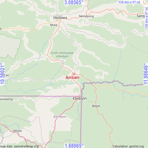
Ambam GPS coordinates[2]
2° 22' 59.988" North, 11° 16' 59.988" East
| Map corner | latitude | longitude |
|---|---|---|
| Upper-left | 3.08565°, | 10.58021° |
| Center: | 2.38333°, | 11.28333° |
| Lower-right: | 1.68065°, | 11.98646° |
| Map W x H: | 156.2×156.2 km | = 97.1×97.1mi |
| max Lat: | 12.57535° ⇑99.2% North |
| Ambam: | 2.38333° |
| min Lat: | ⇓0.8% South 2.35° |
| min Long | Ambam | max Long |
| 8.8724° | 11.28333° | 15.23288° |
| W 53.3%⇐ | ⇒46.7% E |
Elevation
Elevation of Ambam is 570 m = 1870 ft, and this is 103.9 m = 341 ft below average elevation for this country.
| Max E: |
1687 m = 5535 ft | 55.7% |
| Avg. | 673.9 m = 2211 ft | |
| Ambam | 570 m = 1870 ft | |
Min E: |
1 m = 3 ft | 44.3% |
See also: Cameroon elevation on elevation.city.
Geographical zone
Ambam is located in North Torrid zone (between Equator and Tropic of Cancer). Distance of Equator is 265 km =164.7 mi to South.| Distance of | km | miles | from Ambam |
|---|---|---|---|
| North Pole | 9742.1 | 6053.5 | to North |
| Arctic Circle | 7136.2 | 4434.2 | to North |
| Tropic Cancer | 2340.9 | 1454.6 | to North |
| Equator | 265 | 164.7 | to South |


Nearby cities:
15 places around Ambam: (largest is in red/bold)
• Akom II
91.2 km =56.7 mi,  299°
299°
• Akono
124.3 km =77.2 mi,  2°
2°
• Eséka
152.1 km =94.5 mi,  337°
337°
• Kribi
164.7 km =102.3 mi,  291°
291°
• Lolodorf
112.5 km =69.9 mi,  327°
327°
• Maan
74.2 km =46.1 mi,  267°
267°
• Mbalmayo
128.3 km =79.7 mi,  10°
10°
• Mbankomo
156.1 km =97 mi, 4°
• Mvangué
69.8 km =43.4 mi,  21°
21°
• Ngomedzap
96.8 km =60.1 mi,  354°
354°
• Okoa
181.3 km =112.7 mi, 11°
• Okola
181.9 km =113 mi, 3°
• Sangmélima
98.9 km =61.5 mi,  51°
51°
• Yaoundé
167 km =103.8 mi, 8°
• Ébolowa
59.3 km =36.8 mi, 345°
Sources, notices
• [Note1] Compared only with cities in Cameroon existing in our database
• [Src1] Map data: © OpenStreetMap contributors (CC-BY-SA)
• [Src2] Other city data from geonames.org with taken over terms of usage.
• [Src3] Geographical zone / Annual Mean Temperature by Robert A. Rohde @ Wikipedia
