Nguti geodata
Nguti (South-West) is a populated place; located in Cameroon in Africa/Douala (GMT+1) time zone. With population of 5,498 people, there are 98 cities with bigger population in this country. Compared to other cities in Cameroon, 57.4% of cities are located further ↓South; 92.6% of cities are located further →East and 83.6% of cities have higher elevation than Nguti. Note1


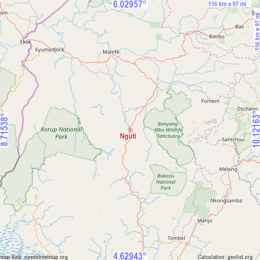
Nguti GPS coordinates[2]
5° 19' 47.64" North, 9° 25' 6.6" East
| Map corner | latitude | longitude |
|---|---|---|
| Upper-left | 6.02957°, | 8.71538° |
| Center: | 5.3299°, | 9.4185° |
| Lower-right: | 4.62943°, | 10.12163° |
| Map W x H: | 155.7×155.7 km | = 96.7×96.7mi |
| max Lat: | 12.57535° ⇑42.6% North |
| Nguti: | 5.3299° |
| min Lat: | ⇓57.4% South 2.35° |
| min Long | Nguti | max Long |
| 8.8724° | 9.4185° | 15.23288° |
| W 7.4%⇐ | ⇒92.6% E |
Elevation
Elevation of Nguti is 228 m = 748 ft, and this is 445.9 m = 1463 ft below average elevation for this country.
| Max E: |
1687 m = 5535 ft | 83.6% |
| Avg. | 673.9 m = 2211 ft | |
| Nguti | 228 m = 748 ft | |
Min E: |
1 m = 3 ft | 16.4% |
See also: Cameroon elevation on elevation.city.
Geographical zone
Nguti is located in North Torrid zone (between Equator and Tropic of Cancer). Distance of Equator is 592.6 km =368.2 mi to South.| Distance of | km | miles | from Nguti |
|---|---|---|---|
| North Pole | 9414.4 | 5849.8 | to North |
| Arctic Circle | 6808.5 | 4230.6 | to North |
| Tropic Cancer | 2013.3 | 1251 | to North |
| Equator | 592.6 | 368.2 | to South |


Nearby cities:
15 places around Nguti: (largest is in red/bold)
• Bafang
86.2 km =53.6 mi,  102°
102°
• Bali
90.3 km =56.1 mi,  46°
46°
• Batibo
74.2 km =46.1 mi,  40°
40°
• Bekondo
72.8 km =45.2 mi,  188°
188°
• Dschang
71.4 km =44.4 mi,  79°
79°
• Fontem
53.6 km =33.3 mi,  73°
73°
• Kumba
77.2 km =48 mi,  177°
177°
• Loum
76.5 km =47.5 mi,  152°
152°
• Mamfe
48.3 km =30 mi,  346°
346°
• Manjo
70.2 km =43.6 mi,  140°
140°
• Mbanga
93.6 km =58.2 mi,  169°
169°
• Melong
64.4 km =40 mi,  111°
111°
• Mundemba
73.9 km =45.9 mi,  234°
234°
• Nkongsamba
71.3 km =44.3 mi,  125°
125°
• Penja
82.1 km =51 mi,  159°
159°
Sources, notices
• [Note1] Compared only with cities in Cameroon existing in our database
• [Src1] Map data: © OpenStreetMap contributors (CC-BY-SA)
• [Src2] Other city data from geonames.org with taken over terms of usage.
• [Src3] Geographical zone / Annual Mean Temperature by Robert A. Rohde @ Wikipedia
