Zunyi geodata
Zunyi (Guizhou) is a populated place; located in China in Asia/Shanghai (GMT+8) time zone. With population of 466,292 people, there are 135 cities with bigger population in this country. Compared to other cities in China, 75.8% of cities are located further ↑North; 84% of cities are located further →East and 83.3% of cities have lower elevation than Zunyi. Note1


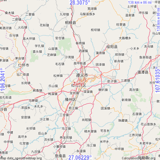
Zunyi GPS coordinates[2]
27° 41' 12.012" North, 106° 54' 25.992" East
| Map corner | latitude | longitude |
|---|---|---|
| Upper-left | 28.3075°, | 106.2041° |
| Center: | 27.68667°, | 106.90722° |
| Lower-right: | 27.06229°, | 107.61035° |
| Map W x H: | 138.5×138.5 km | = 86.1×86.1mi |
| max Lat: | 53.31946° ⇑75.8% North |
| Zunyi: | 27.68667° |
| min Lat: | ⇓24.2% South 18.22056° |
| min Long | Zunyi | max Long |
| 75.07348° | 106.90722° | 134.28917° |
| W 16%⇐ | ⇒84% E |
Elevation
Elevation of Zunyi is 867 m = 2844 ft, and this is 382.2 m = 1254 ft above average elevation for this country.
| Max E: |
5622 m = 18445 ft | 16.7% |
| Zunyi | 867 m 2844 ft | |
| Avg. | 484.8 m = 1591 ft | |
Min E: |
-3 m = -10 ft | 83.3% |
See also: Zunyi elevation on elevation.city.
Geographical zone
Zunyi is located in North temperate zone (between Tropic of Cancer and the Arctic Circle). Distance of this Northern Tropic circle is 472.6 km =293.7 mi to South.| Distance of | km | miles | from Zunyi |
|---|---|---|---|
| North Pole | 6928.6 | 4305.2 | to North |
| Arctic Circle | 4322.7 | 2686 | to North |
| Tropic Cancer | 472.6 | 293.7 | to South |
| Equator | 3078.5 | 1912.9 | to South |


Nearby cities:
15 places around Zunyi: (largest is in red/bold)
• Chumi
61.3 km =38.1 mi,  353°
353°
• Daba
59.7 km =37.1 mi,  307°
307°
• Dahe
71.2 km =44.2 mi, 354°
• Dalucao
53.3 km =33.1 mi,  46°
46°
• Guancang
43.2 km =26.8 mi,  333°
333°
• Hema
69.1 km =42.9 mi,  304°
304°
• Huangyang
69.8 km =43.4 mi,  13°
13°
• Huaqiu
56.4 km =35 mi, 327°
• Jianba
45.6 km =28.3 mi,  16°
16°
• Liziba
58.6 km =36.4 mi, 346°
• Loushanguan
50.7 km =31.5 mi, 350°
• Maoya
51.8 km =32.2 mi,  29°
29°
• Renhuai
51.2 km =31.8 mi,  283°
283°
• Sanhe
69.5 km =43.2 mi, 307°
• Wangcao
59.5 km =37 mi,  36°
36°
Sources, notices
• [Note1] Compared only with cities in China existing in our database
• [Src1] Map data: © OpenStreetMap contributors (CC-BY-SA)
• [Src2] Other city data from geonames.org with taken over terms of usage.
• [Src3] Geographical zone / Annual Mean Temperature by Robert A. Rohde @ Wikipedia
