Huaqiu geodata
Huaqiu (Guizhou) is a seat of a fourth-order administrative division; located in China in Asia/Shanghai (GMT+8) time zone. With population of 1,212 people, there are 1135 cities with bigger population in this country. Compared to other cities in China, 73.1% of cities are located further ↑North; 84.8% of cities are located further →East and 86.1% of cities have lower elevation than Huaqiu. Note1


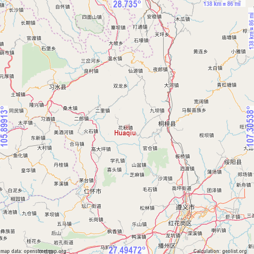
Huaqiu GPS coordinates[2]
28° 6' 59.94" North, 106° 36' 8.1" East
| Map corner | latitude | longitude |
|---|---|---|
| Upper-left | 28.735°, | 105.89913° |
| Center: | 28.11665°, | 106.60225° |
| Lower-right: | 27.49472°, | 107.30538° |
| Map W x H: | 137.9×137.9 km | = 85.7×85.7mi |
| max Lat: | 53.31946° ⇑73.1% North |
| Huaqiu: | 28.11665° |
| min Lat: | ⇓26.9% South 18.22056° |
| min Long | Huaqiu | max Long |
| 75.07348° | 106.60225° | 134.28917° |
| W 15.2%⇐ | ⇒84.8% E |
Elevation
Elevation of Huaqiu is 1050 m = 3445 ft, and this is 565.2 m = 1854 ft above average elevation for this country.
| Max E: |
5622 m = 18445 ft | 13.9% |
| Huaqiu | 1050 m 3445 ft | |
| Avg. | 484.8 m = 1591 ft | |
Min E: |
-3 m = -10 ft | 86.1% |
See also: China elevation on elevation.city.
Geographical zone
Huaqiu is located in North temperate zone (between Tropic of Cancer and the Arctic Circle). Distance of this Northern Tropic circle is 520.4 km =323.4 mi to South.| Distance of | km | miles | from Huaqiu |
|---|---|---|---|
| North Pole | 6880.8 | 4275.5 | to North |
| Arctic Circle | 4274.9 | 2656.3 | to North |
| Tropic Cancer | 520.4 | 323.4 | to South |
| Equator | 3126.3 | 1942.6 | to South |


Nearby cities:
15 places around Huaqiu: (largest is in red/bold)
• Chumi
26.1 km =16.2 mi,  60°
60°
• Daba
20.4 km =12.7 mi,  236°
236°
• Dahe
32.5 km =20.2 mi,  44°
44°
• Guancang
14.2 km =8.8 mi,  129°
129°
• Guandian
19.7 km =12.2 mi,  2°
2°
• Hema
28.3 km =17.6 mi,  252°
252°
• Liangcunchang
36.6 km =22.7 mi,  331°
331°
• Liziba
18.2 km =11.3 mi, 60°
• Loushanguan
21.7 km =13.5 mi,  84°
84°
• Sangmu
34.5 km =21.4 mi,  288°
288°
• Sanhe
25.5 km =15.8 mi,  258°
258°
• Shatan
33 km =20.5 mi,  268°
268°
• Xianyuan
29.7 km =18.5 mi,  359°
359°
• Yelang
36.2 km =22.5 mi,  28°
28°
• Yong’an
19.9 km =12.4 mi,  298°
298°
Sources, notices
• [Note1] Compared only with cities in China existing in our database
• [Src1] Map data: © OpenStreetMap contributors (CC-BY-SA)
• [Src2] Other city data from geonames.org with taken over terms of usage.
• [Src3] Geographical zone / Annual Mean Temperature by Robert A. Rohde @ Wikipedia
