Bamaoxi geodata
Bamaoxi (Hunan) is a seat of a fourth-order administrative division; located in China in Asia/Shanghai (GMT+8) time zone. In our database, there are 1268 cities with bigger population. Compared to other cities in China, 57.8% of cities are located further ↑North; 71.1% of cities are located further →East and 68.7% of cities have lower elevation than Bamaoxi. Note1


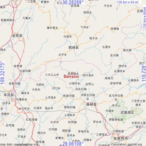
Bamaoxi GPS coordinates[2]
29° 40' 25.824" North, 110° 1' 29.532" East
| Map corner | latitude | longitude |
|---|---|---|
| Upper-left | 30.28289°, | 109.32175° |
| Center: | 29.67384°, | 110.02487° |
| Lower-right: | 29.06108°, | 110.728° |
| Map W x H: | 135.9×135.9 km | = 84.4×84.4mi |
| max Lat: | 53.31946° ⇑57.8% North |
| Bamaoxi: | 29.67384° |
| min Lat: | ⇓42.2% South 18.22056° |
| min Long | Bamaoxi | max Long |
| 75.07348° | 110.02487° | 134.28917° |
| W 28.9%⇐ | ⇒71.1% E |
Elevation
Elevation of Bamaoxi is 388 m = 1273 ft, and this is 96.8 m = 318 ft below average elevation for this country.
| Max E: |
5622 m = 18445 ft | 31.3% |
| Avg. | 484.8 m = 1591 ft | |
| Bamaoxi | 388 m = 1273 ft | |
Min E: |
-3 m = -10 ft | 68.7% |
See also: China elevation on elevation.city.
Geographical zone
Bamaoxi is located in North temperate zone (between Tropic of Cancer and the Arctic Circle). Distance of this Northern Tropic circle is 693.5 km =430.9 mi to South.| Distance of | km | miles | from Bamaoxi |
|---|---|---|---|
| North Pole | 6707.6 | 4167.9 | to North |
| Arctic Circle | 4101.8 | 2548.7 | to North |
| Tropic Cancer | 693.5 | 430.9 | to South |
| Equator | 3299.4 | 2050.2 | to South |


Nearby cities:
15 places around Bamaoxi: (largest is in red/bold)
• Chenjiahe
21.4 km =13.3 mi,  192°
192°
• Guluoshan
18.8 km =11.7 mi,  120°
120°
• Jianjiapo
15 km =9.3 mi,  206°
206°
• Kuzhuping
6.5 km =4 mi, 117°
• Liangshuikou
16.3 km =10.1 mi,  154°
154°
• Longtanping
12.7 km =7.9 mi,  88°
88°
• Pailou
21.3 km =13.2 mi,  229°
229°
• Rongmei
24.4 km =15.2 mi,  0°
0°
• Shadiping
19.7 km =12.2 mi,  267°
267°
• Shataping
9.6 km =6 mi,  172°
172°
• Sifangxi
14 km =8.7 mi,  96°
96°
• Taiping
20.2 km =12.6 mi,  330°
330°
• Wangjiaping
11.3 km =7 mi,  287°
287°
• Yanwukou
21.9 km =13.6 mi, 208°
• Zhangjiaqiao
21.7 km =13.5 mi, 148°
Sources, notices
• [Note1] Compared only with cities in China existing in our database
• [Src1] Map data: © OpenStreetMap contributors (CC-BY-SA)
• [Src2] Other city data from geonames.org with taken over terms of usage.
• [Src3] Geographical zone / Annual Mean Temperature by Robert A. Rohde @ Wikipedia
