Wangjiaping geodata
Wangjiaping (Hunan) is a seat of a fourth-order administrative division; located in China in Asia/Shanghai (GMT+8) time zone. In our database, there are 1268 cities with bigger population. Compared to other cities in China, 57.4% of cities are located further ↑North; 71.7% of cities are located further →East and 73% of cities have lower elevation than Wangjiaping. Note1


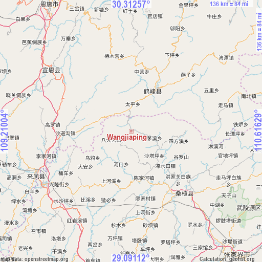
Wangjiaping GPS coordinates[2]
29° 42' 13.32" North, 109° 54' 47.376" East
| Map corner | latitude | longitude |
|---|---|---|
| Upper-left | 30.31257°, | 109.21004° |
| Center: | 29.7037°, | 109.91316° |
| Lower-right: | 29.09112°, | 110.61629° |
| Map W x H: | 135.8×135.8 km | = 84.4×84.4mi |
| max Lat: | 53.31946° ⇑57.4% North |
| Wangjiaping: | 29.7037° |
| min Lat: | ⇓42.6% South 18.22056° |
| min Long | Wangjiaping | max Long |
| 75.07348° | 109.91316° | 134.28917° |
| W 28.3%⇐ | ⇒71.7% E |
Elevation
Elevation of Wangjiaping is 476 m = 1562 ft, and this is 8.8 m = 29 ft below average elevation for this country.
| Max E: |
5622 m = 18445 ft | 27% |
| Avg. | 484.8 m = 1591 ft | |
| Wangjiaping | 476 m = 1562 ft | |
Min E: |
-3 m = -10 ft | 73% |
See also: China elevation on elevation.city.
Geographical zone
Wangjiaping is located in North temperate zone (between Tropic of Cancer and the Arctic Circle). Distance of this Northern Tropic circle is 696.8 km =433 mi to South.| Distance of | km | miles | from Wangjiaping |
|---|---|---|---|
| North Pole | 6704.3 | 4165.9 | to North |
| Arctic Circle | 4098.4 | 2546.6 | to North |
| Tropic Cancer | 696.8 | 433 | to South |
| Equator | 3302.7 | 2052.2 | to South |


Nearby cities:
15 places around Wangjiaping: (largest is in red/bold)
• Bamaoxi
11.3 km =7 mi,  107°
107°
• Chenjiahe
25 km =15.5 mi,  165°
165°
• Jianjiapo
17.3 km =10.7 mi, 166°
• Kuzhuping
17.7 km =11 mi, 110°
• Liangshuikou
25.3 km =15.7 mi,  135°
135°
• Longtanping
23.7 km =14.7 mi,  97°
97°
• Pailou
17.9 km =11.1 mi,  197°
197°
• Rongmei
23.7 km =14.7 mi,  27°
27°
• Shadiping
9.8 km =6.1 mi,  244°
244°
• Shanghexi
27.5 km =17.1 mi, 202°
• Shataping
17.6 km =10.9 mi, 136°
• Sifangxi
25.2 km =15.7 mi, 101°
• Taiping
14.3 km =8.9 mi,  3°
3°
• Wuyahe
24 km =14.9 mi,  233°
233°
• Yanwukou
22.5 km =14 mi,  179°
179°
Sources, notices
• [Note1] Compared only with cities in China existing in our database
• [Src1] Map data: © OpenStreetMap contributors (CC-BY-SA)
• [Src2] Other city data from geonames.org with taken over terms of usage.
• [Src3] Geographical zone / Annual Mean Temperature by Robert A. Rohde @ Wikipedia
