Shadiping geodata
Shadiping (Hunan) is a seat of a fourth-order administrative division; located in China in Asia/Shanghai (GMT+8) time zone. In our database, there are 1268 cities with bigger population. Compared to other cities in China, 57.8% of cities are located further ↑North; 72.2% of cities are located further →East and 85.8% of cities have lower elevation than Shadiping. Note1


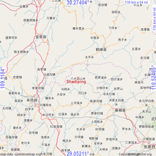
Shadiping GPS coordinates[2]
29° 39' 53.748" North, 109° 49' 17.472" East
| Map corner | latitude | longitude |
|---|---|---|
| Upper-left | 30.27404°, | 109.1184° |
| Center: | 29.66493°, | 109.82152° |
| Lower-right: | 29.05211°, | 110.52465° |
| Map W x H: | 135.9×135.9 km | = 84.4×84.4mi |
| max Lat: | 53.31946° ⇑57.8% North |
| Shadiping: | 29.66493° |
| min Lat: | ⇓42.2% South 18.22056° |
| min Long | Shadiping | max Long |
| 75.07348° | 109.82152° | 134.28917° |
| W 27.8%⇐ | ⇒72.2% E |
Elevation
Elevation of Shadiping is 1034 m = 3392 ft, and this is 549.2 m = 1802 ft above average elevation for this country.
| Max E: |
5622 m = 18445 ft | 14.2% |
| Shadiping | 1034 m 3392 ft | |
| Avg. | 484.8 m = 1591 ft | |
Min E: |
-3 m = -10 ft | 85.8% |
See also: China elevation on elevation.city.
Geographical zone
Shadiping is located in North temperate zone (between Tropic of Cancer and the Arctic Circle). Distance of this Northern Tropic circle is 692.5 km =430.3 mi to South.| Distance of | km | miles | from Shadiping |
|---|---|---|---|
| North Pole | 6708.6 | 4168.5 | to North |
| Arctic Circle | 4102.7 | 2549.3 | to North |
| Tropic Cancer | 692.5 | 430.3 | to South |
| Equator | 3298.4 | 2049.5 | to South |


Nearby cities:
15 places around Shadiping: (largest is in red/bold)
• Bamaoxi
19.7 km =12.2 mi,  87°
87°
• Chenjiahe
24.9 km =15.5 mi,  142°
142°
• Da’anping
20.4 km =12.7 mi,  225°
225°
• Jianjiapo
18 km =11.2 mi,  133°
133°
• Kuzhuping
25.5 km =15.8 mi, 94°
• Pailou
13.2 km =8.2 mi,  164°
164°
• Shadaogou
25.8 km =16 mi,  277°
277°
• Shanghexi
21.1 km =13.1 mi,  184°
184°
• Shataping
22.6 km =14 mi,  112°
112°
• Shipaidong
24.9 km =15.5 mi,  245°
245°
• Shuitianba
25.5 km =15.8 mi,  202°
202°
• Taiping
21 km =13 mi,  27°
27°
• Wangjiaping
9.8 km =6.1 mi,  64°
64°
• Wuyahe
14.4 km =8.9 mi, 227°
• Yanwukou
20.4 km =12.7 mi,  153°
153°
Sources, notices
• [Note1] Compared only with cities in China existing in our database
• [Src1] Map data: © OpenStreetMap contributors (CC-BY-SA)
• [Src2] Other city data from geonames.org with taken over terms of usage.
• [Src3] Geographical zone / Annual Mean Temperature by Robert A. Rohde @ Wikipedia
