Yuecheng geodata
Yuecheng (Sichuan) is a seat of a third-order administrative division; located in China in Asia/Shanghai (GMT+8) time zone. In our database, there are 1268 cities with bigger population. Compared to other cities in China, 68.5% of cities are located further ↑North; 92.3% of cities are located further →East and 92.8% of cities have lower elevation than Yuecheng. Note1


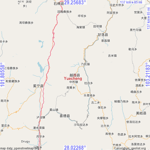
Yuecheng GPS coordinates[2]
28° 38' 29.652" North, 102° 30' 31.32" East
| Map corner | latitude | longitude |
|---|---|---|
| Upper-left | 29.25683°, | 101.80558° |
| Center: | 28.64157°, | 102.5087° |
| Lower-right: | 28.02268°, | 103.21183° |
| Map W x H: | 137.2×137.2 km | = 85.3×85.3mi |
| max Lat: | 53.31946° ⇑68.5% North |
| Yuecheng: | 28.64157° |
| min Lat: | ⇓31.5% South 18.22056° |
| min Long | Yuecheng | max Long |
| 75.07348° | 102.5087° | 134.28917° |
| W 7.7%⇐ | ⇒92.3% E |
Elevation
Elevation of Yuecheng is 1679 m = 5509 ft, and this is 1194.2 m = 3918 ft above average elevation for this country.
| Max E: |
5622 m = 18445 ft | 7.2% |
| Yuecheng | 1679 m 5509 ft | |
| Avg. | 484.8 m = 1591 ft | |
Min E: |
-3 m = -10 ft | 92.8% |
See also: China elevation on elevation.city.
Geographical zone
Yuecheng is located in North temperate zone (between Tropic of Cancer and the Arctic Circle). Distance of this Northern Tropic circle is 578.7 km =359.6 mi to South.| Distance of | km | miles | from Yuecheng |
|---|---|---|---|
| North Pole | 6822.4 | 4239.2 | to North |
| Arctic Circle | 4216.5 | 2620 | to North |
| Tropic Cancer | 578.7 | 359.6 | to South |
| Equator | 3184.6 | 1978.8 | to South |


Nearby cities:
15 places around Yuecheng: (largest is in red/bold)
• Chengxiang
34.7 km =21.6 mi,  253°
253°
• Guangming
38 km =23.6 mi,  194°
194°
• Hepingyizu
87.5 km =54.4 mi,  39°
39°
• Jincheng
111.7 km =69.4 mi,  111°
111°
• Minjian
103.6 km =64.4 mi,  77°
77°
• Shaping
98.6 km =61.3 mi,  48°
48°
• Shirong
80.1 km =49.8 mi,  10°
10°
• Temuli
107.9 km =67 mi,  164°
164°
• Tiandiba
127.2 km =79 mi,  145°
145°
• Xia’er
105 km =65.2 mi,  292°
292°
• Xichang
86.3 km =53.6 mi,  196°
196°
• Xiluodu
119 km =73.9 mi, 111°
• Xincheng
76.9 km =47.8 mi, 154°
• Xinmian
67.8 km =42.1 mi,  348°
348°
• Xinshiba
44.7 km =27.8 mi,  34°
34°
Sources, notices
• [Note1] Compared only with cities in China existing in our database
• [Src1] Map data: © OpenStreetMap contributors (CC-BY-SA)
• [Src2] Other city data from geonames.org with taken over terms of usage.
• [Src3] Geographical zone / Annual Mean Temperature by Robert A. Rohde @ Wikipedia
