Xiazhuang geodata
Xiazhuang (Shandong) is a populated place; located in China in Asia/Shanghai (GMT+8) time zone. With population of 63,285 people, there are 683 cities with bigger population in this country. Compared to other cities in China, 74.7% of cities are located further ↓South; 74.1% of cities are located further ←West and 68% of cities have higher elevation than Xiazhuang. Note1


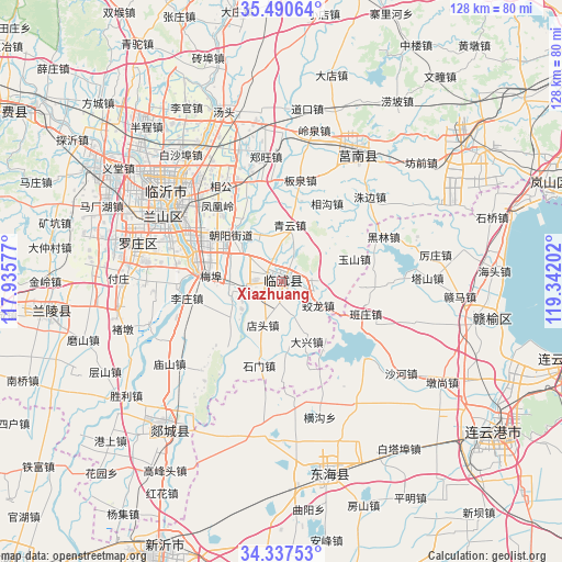
Xiazhuang GPS coordinates[2]
34° 54' 57.996" North, 118° 38' 20.004" East
| Map corner | latitude | longitude |
|---|---|---|
| Upper-left | 35.49064°, | 117.93577° |
| Center: | 34.91611°, | 118.63889° |
| Lower-right: | 34.33753°, | 119.34202° |
| Map W x H: | 128.2×128.2 km | = 79.7×79.7mi |
| max Lat: | 53.31946° ⇑25.3% North |
| Xiazhuang: | 34.91611° |
| min Lat: | ⇓74.7% South 18.22056° |
| min Long | Xiazhuang | max Long |
| 75.07348° | 118.63889° | 134.28917° |
| W 74.1%⇐ | ⇒25.9% E |
Elevation
Elevation of Xiazhuang is 60 m = 197 ft, and this is 424.8 m = 1394 ft below average elevation for this country.
| Max E: |
5622 m = 18445 ft | 68% |
| Avg. | 484.8 m = 1591 ft | |
| Xiazhuang | 60 m = 197 ft | |
Min E: |
-3 m = -10 ft | 32% |
See also: Xiazhuang elevation on elevation.city.
Geographical zone
Xiazhuang is located in North temperate zone (between Tropic of Cancer and the Arctic Circle). Distance of this Northern Tropic circle is 1276.4 km =793.1 mi to South.| Distance of | km | miles | from Xiazhuang |
|---|---|---|---|
| North Pole | 6124.8 | 3805.8 | to North |
| Arctic Circle | 3518.9 | 2186.5 | to North |
| Tropic Cancer | 1276.4 | 793.1 | to South |
| Equator | 3882.3 | 2412.3 | to South |


Nearby cities:
15 places around Xiazhuang: (largest is in red/bold)
• Andongwei
62.7 km =39 mi,  67°
67°
• Bianzhuang
54.7 km =34 mi,  262°
262°
• Dunshang
43.2 km =26.8 mi,  122°
122°
• Haitou
48.4 km =30.1 mi,  87°
87°
• Haizhou
58.2 km =36.2 mi,  129°
129°
• Huaguoshan
62.3 km =38.7 mi, 119°
• Jinping
62.3 km =38.7 mi,  135°
135°
• Linyi
31.5 km =19.6 mi,  301°
301°
• Luoyang
48.4 km =30.1 mi, 118°
• Niushan
45.1 km =28 mi,  165°
165°
• Qingkou
43.5 km =27 mi,  99°
99°
• Shizilu
33.2 km =20.6 mi,  31°
31°
• Songzhuang
48.1 km =29.9 mi,  107°
107°
• Tancheng
43.3 km =26.9 mi,  219°
219°
• Xinpu
59.2 km =36.8 mi, 126°
Sources, notices
• [Note1] Compared only with cities in China existing in our database
• [Src1] Map data: © OpenStreetMap contributors (CC-BY-SA)
• [Src2] Other city data from geonames.org with taken over terms of usage.
• [Src3] Geographical zone / Annual Mean Temperature by Robert A. Rohde @ Wikipedia
