Shizilu geodata
Shizilu (Shandong) is a populated place; located in China in Asia/Shanghai (GMT+8) time zone. With population of 86,749 people, there are 491 cities with bigger population in this country. Compared to other cities in China, 75.4% of cities are located further ↓South; 75.1% of cities are located further ←West and 59.5% of cities have higher elevation than Shizilu. Note1


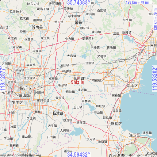
Shizilu GPS coordinates[2]
35° 10' 15.996" North, 118° 49' 44.004" East
| Map corner | latitude | longitude |
|---|---|---|
| Upper-left | 35.74383°, | 118.12577° |
| Center: | 35.17111°, | 118.82889° |
| Lower-right: | 34.59432°, | 119.53202° |
| Map W x H: | 127.8×127.8 km | = 79.4×79.4mi |
| max Lat: | 53.31946° ⇑24.6% North |
| Shizilu: | 35.17111° |
| min Lat: | ⇓75.4% South 18.22056° |
| min Long | Shizilu | max Long |
| 75.07348° | 118.82889° | 134.28917° |
| W 75.1%⇐ | ⇒24.9% E |
Elevation
Elevation of Shizilu is 101 m = 331 ft, and this is 383.8 m = 1259 ft below average elevation for this country.
| Max E: |
5622 m = 18445 ft | 59.5% |
| Avg. | 484.8 m = 1591 ft | |
| Shizilu | 101 m = 331 ft | |
Min E: |
-3 m = -10 ft | 40.5% |
See also: Shizilu elevation on elevation.city.
Geographical zone
Shizilu is located in North temperate zone (between Tropic of Cancer and the Arctic Circle). Distance of this Northern Tropic circle is 1304.7 km =810.7 mi to South.| Distance of | km | miles | from Shizilu |
|---|---|---|---|
| North Pole | 6096.4 | 3788.1 | to North |
| Arctic Circle | 3490.5 | 2168.9 | to North |
| Tropic Cancer | 1304.7 | 810.7 | to South |
| Equator | 3910.7 | 2430 | to South |


Nearby cities:
15 places around Shizilu: (largest is in red/bold)
• Andongwei
40.9 km =25.4 mi,  96°
96°
• Chaoyang
69.2 km =43 mi,  141°
141°
• Chengyang
45.4 km =28.2 mi,  0°
0°
• Dunshang
54.9 km =34.1 mi,  159°
159°
• Haitou
40.7 km =25.3 mi,  130°
130°
• Huaguoshan
69.5 km =43.2 mi,  147°
147°
• Jiehu
53.5 km =33.2 mi,  320°
320°
• Linyi
45.8 km =28.5 mi,  254°
254°
• Luoyang
57.1 km =35.5 mi, 153°
• Qingkou
44 km =27.3 mi, 144°
• Rizhao
63.6 km =39.5 mi,  63°
63°
• Rizhao
68.5 km =42.6 mi,  68°
68°
• Songzhuang
51.6 km =32.1 mi, 146°
• Xiazhuang
33.2 km =20.6 mi,  211°
211°
• Xinpu
70.3 km =43.7 mi, 154°
Sources, notices
• [Note1] Compared only with cities in China existing in our database
• [Src1] Map data: © OpenStreetMap contributors (CC-BY-SA)
• [Src2] Other city data from geonames.org with taken over terms of usage.
• [Src3] Geographical zone / Annual Mean Temperature by Robert A. Rohde @ Wikipedia
