Bianzhuang geodata
Bianzhuang (Shandong) is a populated place; located in China in Asia/Shanghai (GMT+8) time zone. With population of 65,381 people, there are 665 cities with bigger population in this country. Compared to other cities in China, 74.5% of cities are located further ↓South; 70.8% of cities are located further ←West and 71.9% of cities have higher elevation than Bianzhuang. Note1


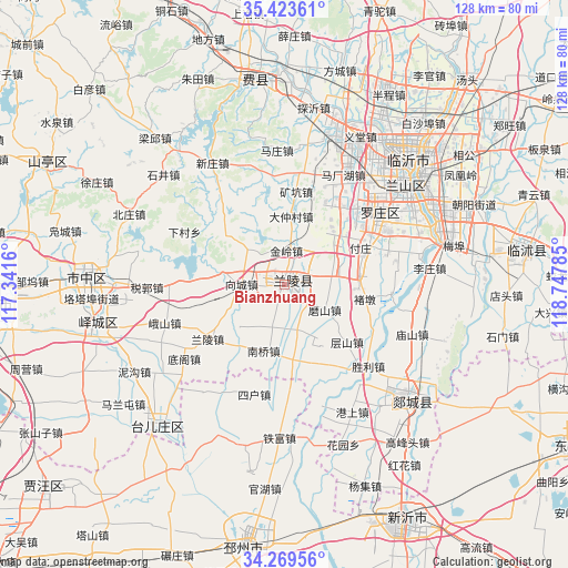
Bianzhuang GPS coordinates[2]
34° 50' 54.996" North, 118° 2' 40.992" East
| Map corner | latitude | longitude |
|---|---|---|
| Upper-left | 35.42361°, | 117.3416° |
| Center: | 34.84861°, | 118.04472° |
| Lower-right: | 34.26956°, | 118.74785° |
| Map W x H: | 128.3×128.3 km | = 79.7×79.7mi |
| max Lat: | 53.31946° ⇑25.5% North |
| Bianzhuang: | 34.84861° |
| min Lat: | ⇓74.5% South 18.22056° |
| min Long | Bianzhuang | max Long |
| 75.07348° | 118.04472° | 134.28917° |
| W 70.8%⇐ | ⇒29.2% E |
Elevation
Elevation of Bianzhuang is 45 m = 148 ft, and this is 439.8 m = 1443 ft below average elevation for this country.
| Max E: |
5622 m = 18445 ft | 71.9% |
| Avg. | 484.8 m = 1591 ft | |
| Bianzhuang | 45 m = 148 ft | |
Min E: |
-3 m = -10 ft | 28.1% |
See also: Bianzhuang elevation on elevation.city.
Geographical zone
Bianzhuang is located in North temperate zone (between Tropic of Cancer and the Arctic Circle). Distance of this Northern Tropic circle is 1268.9 km =788.5 mi to South.| Distance of | km | miles | from Bianzhuang |
|---|---|---|---|
| North Pole | 6132.3 | 3810.4 | to North |
| Arctic Circle | 3526.4 | 2191.2 | to North |
| Tropic Cancer | 1268.9 | 788.5 | to South |
| Equator | 3874.8 | 2407.7 | to South |


Nearby cities:
15 places around Bianzhuang: (largest is in red/bold)
• Chengtangcun
82.1 km =51 mi,  288°
288°
• Dunshang
92.1 km =57.2 mi,  99°
99°
• Feicheng
46.3 km =28.8 mi,  351°
351°
• Jiehu
85.7 km =53.3 mi,  25°
25°
• Linyi
36.1 km =22.4 mi,  48°
48°
• Niushan
75.1 km =46.7 mi,  118°
118°
• Pingyi
81.7 km =50.8 mi,  332°
332°
• Pizhou
60.4 km =37.5 mi,  188°
188°
• Shanting
59.1 km =36.7 mi,  295°
295°
• Shizilu
79.9 km =49.6 mi,  63°
63°
• Tancheng
37.3 km =23.2 mi,  134°
134°
• Taozhuang
64.9 km =40.3 mi,  270°
270°
• Xiazhen
85.3 km =53 mi, 266°
• Xiazhuang
54.7 km =34 mi,  82°
82°
• Zaozhuang
44.8 km =27.8 mi, 272°
Sources, notices
• [Note1] Compared only with cities in China existing in our database
• [Src1] Map data: © OpenStreetMap contributors (CC-BY-SA)
• [Src2] Other city data from geonames.org with taken over terms of usage.
• [Src3] Geographical zone / Annual Mean Temperature by Robert A. Rohde @ Wikipedia
