Wantang geodata
Wantang (Hunan) is a populated place; located in China in Asia/Shanghai (GMT+8) time zone. With population of 880 people, there are 1202 cities with bigger population in this country. Compared to other cities in China, 80.3% of cities are located further ↑North; 68.1% of cities are located further →East and 68.1% of cities have lower elevation than Wantang. Note1


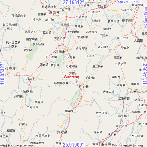
Wantang GPS coordinates[2]
26° 32' 26.988" North, 110° 45' 23.004" East
| Map corner | latitude | longitude |
|---|---|---|
| Upper-left | 27.16812°, | 110.05327° |
| Center: | 26.54083°, | 110.75639° |
| Lower-right: | 25.91009°, | 111.45952° |
| Map W x H: | 139.9×139.9 km | = 86.9×86.9mi |
| max Lat: | 53.31946° ⇑80.3% North |
| Wantang: | 26.54083° |
| min Lat: | ⇓19.7% South 18.22056° |
| min Long | Wantang | max Long |
| 75.07348° | 110.75639° | 134.28917° |
| W 31.9%⇐ | ⇒68.1% E |
Elevation
Elevation of Wantang is 379 m = 1243 ft, and this is 105.8 m = 347 ft below average elevation for this country.
| Max E: |
5622 m = 18445 ft | 31.9% |
| Avg. | 484.8 m = 1591 ft | |
| Wantang | 379 m = 1243 ft | |
Min E: |
-3 m = -10 ft | 68.1% |
See also: China elevation on elevation.city.
Geographical zone
Wantang is located in North temperate zone (between Tropic of Cancer and the Arctic Circle). Distance of this Northern Tropic circle is 345.1 km =214.4 mi to South.| Distance of | km | miles | from Wantang |
|---|---|---|---|
| North Pole | 7056 | 4384.4 | to North |
| Arctic Circle | 4450.1 | 2765.2 | to North |
| Tropic Cancer | 345.1 | 214.4 | to South |
| Equator | 2951.1 | 1833.7 | to South |


Nearby cities:
15 places around Wantang: (largest is in red/bold)
• Baisha
17.5 km =10.9 mi,  96°
96°
• Dengyuantai
26.9 km =16.7 mi,  307°
307°
• Gaoqiao
17.6 km =10.9 mi,  54°
54°
• Huangjin Yaozuxiang
24.1 km =15 mi,  236°
236°
• Huanglong
17.7 km =11 mi,  89°
89°
• Jiangfang
41 km =25.5 mi,  263°
263°
• Jinshi
14.3 km =8.9 mi,  162°
162°
• Langshan
18.7 km =11.6 mi, 162°
• Malin
14.9 km =9.3 mi,  230°
230°
• Maoping
34.3 km =21.3 mi,  266°
266°
• Qingjiangqiao
23.8 km =14.8 mi,  72°
72°
• Qingxi
41.8 km =26 mi,  253°
253°
• Wantouqiao
36.1 km =22.4 mi,  337°
337°
• Xiyan
29.3 km =18.2 mi,  286°
286°
• Yaoshi
27.7 km =17.2 mi,  173°
173°
Sources, notices
• [Note1] Compared only with cities in China existing in our database
• [Src1] Map data: © OpenStreetMap contributors (CC-BY-SA)
• [Src2] Other city data from geonames.org with taken over terms of usage.
• [Src3] Geographical zone / Annual Mean Temperature by Robert A. Rohde @ Wikipedia
