Sanhe geodata
Sanhe (Ningxia Hui Autonomous Region) is a seat of a third-order administrative division; located in China in Asia/Shanghai (GMT+8) time zone. In our database, there are 1268 cities with bigger population. Compared to other cities in China, 78.4% of cities are located further ↓South; 88% of cities are located further →East and 93.9% of cities have lower elevation than Sanhe. Note1


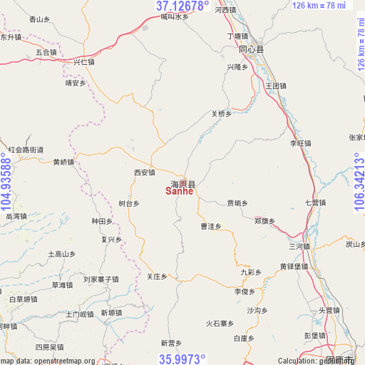
Sanhe GPS coordinates[2]
36° 33' 50.76" North, 105° 38' 20.4" East
| Map corner | latitude | longitude |
|---|---|---|
| Upper-left | 37.12678°, | 104.93588° |
| Center: | 36.5641°, | 105.639° |
| Lower-right: | 35.9973°, | 106.34213° |
| Map W x H: | 125.6×125.6 km | = 78×78mi |
| max Lat: | 53.31946° ⇑21.6% North |
| Sanhe: | 36.5641° |
| min Lat: | ⇓78.4% South 18.22056° |
| min Long | Sanhe | max Long |
| 75.07348° | 105.639° | 134.28917° |
| W 12%⇐ | ⇒88% E |
Elevation
Elevation of Sanhe is 1853 m = 6079 ft, and this is 1368.2 m = 4489 ft above average elevation for this country.
| Max E: |
5622 m = 18445 ft | 6.1% |
| Sanhe | 1853 m 6079 ft | |
| Avg. | 484.8 m = 1591 ft | |
Min E: |
-3 m = -10 ft | 93.9% |
See also: China elevation on elevation.city.
Geographical zone
Sanhe is located in North temperate zone (between Tropic of Cancer and the Arctic Circle). Distance of this Northern Tropic circle is 1459.6 km =907 mi to South.| Distance of | km | miles | from Sanhe |
|---|---|---|---|
| North Pole | 5941.5 | 3691.9 | to North |
| Arctic Circle | 3335.6 | 2072.6 | to North |
| Tropic Cancer | 1459.6 | 907 | to South |
| Equator | 4065.5 | 2526.2 | to South |


Nearby cities:
15 places around Sanhe: (largest is in red/bold)
• Gancheng
62.6 km =38.9 mi,  87°
87°
• Gaotai
67.2 km =41.8 mi,  100°
100°
• Gongbailiang
63.4 km =39.4 mi,  109°
109°
• Heicheng
45.4 km =28.2 mi,  118°
118°
• Huangduobu
47.7 km =29.6 mi,  126°
126°
• Liwang
42.8 km =26.6 mi,  74°
74°
• Luochuan
32.8 km =20.4 mi,  80°
80°
• Qiying
46 km =28.6 mi, 98°
• Sanying
55.9 km =34.7 mi, 124°
• Tanshan
63 km =39.1 mi, 109°
• Touying
68.3 km =42.4 mi, 130°
• Yanglang
60.6 km =37.7 mi, 128°
• Yanglu
45.6 km =28.3 mi, 79°
• Yuhai
52.1 km =32.4 mi,  27°
27°
• Zhangjiayuan
64.4 km =40 mi, 74°
Sources, notices
• [Note1] Compared only with cities in China existing in our database
• [Src1] Map data: © OpenStreetMap contributors (CC-BY-SA)
• [Src2] Other city data from geonames.org with taken over terms of usage.
• [Src3] Geographical zone / Annual Mean Temperature by Robert A. Rohde @ Wikipedia
