Ning’an geodata
Ning’an (Ningxia Hui Autonomous Region) is a seat of a third-order administrative division; located in China in Asia/Shanghai (GMT+8) time zone. In our database, there are 1268 cities with bigger population. Compared to other cities in China, 80.2% of cities are located further ↓South; 87.9% of cities are located further →East and 88% of cities have lower elevation than Ning’an. Note1


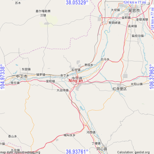
Ning’an GPS coordinates[2]
37° 29' 51.108" North, 105° 40' 35.4" East
| Map corner | latitude | longitude |
|---|---|---|
| Upper-left | 38.05329°, | 104.97338° |
| Center: | 37.49753°, | 105.6765° |
| Lower-right: | 36.93761°, | 106.37963° |
| Map W x H: | 124.1×124.1 km | = 77.1×77.1mi |
| max Lat: | 53.31946° ⇑19.8% North |
| Ning’an: | 37.49753° |
| min Lat: | ⇓80.2% South 18.22056° |
| min Long | Ning’an | max Long |
| 75.07348° | 105.6765° | 134.28917° |
| W 12.1%⇐ | ⇒87.9% E |
Elevation
Elevation of Ning’an is 1187 m = 3894 ft, and this is 702.2 m = 2304 ft above average elevation for this country.
| Max E: |
5622 m = 18445 ft | 12% |
| Ning’an | 1187 m 3894 ft | |
| Avg. | 484.8 m = 1591 ft | |
Min E: |
-3 m = -10 ft | 88% |
See also: China elevation on elevation.city.
Geographical zone
Ning’an is located in North temperate zone (between Tropic of Cancer and the Arctic Circle). Distance of this Northern Tropic circle is 1563.4 km =971.5 mi to South.| Distance of | km | miles | from Ning’an |
|---|---|---|---|
| North Pole | 5837.7 | 3627.4 | to North |
| Arctic Circle | 3231.8 | 2008.1 | to North |
| Tropic Cancer | 1563.4 | 971.5 | to South |
| Equator | 4169.3 | 2590.7 | to South |


Nearby cities:
15 places around Ning’an: (largest is in red/bold)
• Binhe
43.4 km =27 mi,  271°
271°
• Dongta
87.5 km =54.4 mi,  42°
42°
• Hongsipu
35.6 km =22.1 mi,  107°
107°
• Liwang
99.7 km =62 mi,  157°
157°
• Luochuan
102.6 km =63.8 mi, 163°
• Magaozhuang
97 km =60.3 mi,  135°
135°
• Sanhe
103.8 km =64.5 mi,  181°
181°
• Shengli
70.9 km =44.1 mi, 40°
• Wuzhong
71.3 km =44.3 mi, 40°
• Yanghe
100.3 km =62.3 mi,  29°
29°
• Yanglu
104.2 km =64.7 mi, 156°
• Yuhai
60.9 km =37.8 mi, 160°
• Yuwang
97.7 km =60.7 mi, 140°
• Zhangjiayuan
104.1 km =64.7 mi,  145°
145°
• Zhongwei
42.9 km =26.7 mi, 272°
Sources, notices
• [Note1] Compared only with cities in China existing in our database
• [Src1] Map data: © OpenStreetMap contributors (CC-BY-SA)
• [Src2] Other city data from geonames.org with taken over terms of usage.
• [Src3] Geographical zone / Annual Mean Temperature by Robert A. Rohde @ Wikipedia
