Taojiahe geodata
Taojiahe (Hubei) is a seat of a fourth-order administrative division; located in China in Asia/Shanghai (GMT+8) time zone. In our database, there are 1268 cities with bigger population. Compared to other cities in China, 54% of cities are located further ↓South; 59.7% of cities are located further ←West and 75.7% of cities have lower elevation than Taojiahe. Note1


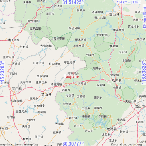
Taojiahe GPS coordinates[2]
30° 54' 46.476" North, 115° 56' 6.54" East
| Map corner | latitude | longitude |
|---|---|---|
| Upper-left | 31.51425°, | 115.23203° |
| Center: | 30.91291°, | 115.93515° |
| Lower-right: | 30.30777°, | 116.63828° |
| Map W x H: | 134.1×134.1 km | = 83.3×83.3mi |
| max Lat: | 53.31946° ⇑46% North |
| Taojiahe: | 30.91291° |
| min Lat: | ⇓54% South 18.22056° |
| min Long | Taojiahe | max Long |
| 75.07348° | 115.93515° | 134.28917° |
| W 59.7%⇐ | ⇒40.3% E |
Elevation
Elevation of Taojiahe is 537 m = 1762 ft, and this is 52.2 m = 171 ft above average elevation for this country.
| Max E: |
5622 m = 18445 ft | 24.3% |
| Taojiahe | 537 m 1762 ft | |
| Avg. | 484.8 m = 1591 ft | |
Min E: |
-3 m = -10 ft | 75.7% |
See also: China elevation on elevation.city.
Geographical zone
Taojiahe is located in North temperate zone (between Tropic of Cancer and the Arctic Circle). Distance of this Northern Tropic circle is 831.3 km =516.5 mi to South.| Distance of | km | miles | from Taojiahe |
|---|---|---|---|
| North Pole | 6569.9 | 4082.3 | to North |
| Arctic Circle | 3964 | 2463.1 | to North |
| Tropic Cancer | 831.3 | 516.5 | to South |
| Equator | 3437.2 | 2135.8 | to South |


Nearby cities:
15 places around Taojiahe: (largest is in red/bold)
• Baimiaohe
33.3 km =20.7 mi,  287°
287°
• Caodipan
10.8 km =6.7 mi,  341°
341°
• Dahe’an
44.5 km =27.7 mi,  259°
259°
• Fangjiazui
43.1 km =26.8 mi,  226°
226°
• Hongshan
31.5 km =19.6 mi,  239°
239°
• Jinjiapu
28.6 km =17.8 mi,  265°
265°
• Jiuzihe
35.7 km =22.2 mi,  315°
315°
• Kongjiafang
30.3 km =18.8 mi,  254°
254°
• Kuanghe
43 km =26.7 mi, 237°
• Leijiadian
17.7 km =11 mi, 260°
• Shitouzui
19.6 km =12.2 mi,  297°
297°
• Tanlin
44.3 km =27.5 mi,  190°
190°
• Tiantang
40.2 km =25 mi,  100°
100°
• Wenquan
23.6 km =14.7 mi, 252°
• Yangliuwan
18.6 km =11.6 mi, 236°
Sources, notices
• [Note1] Compared only with cities in China existing in our database
• [Src1] Map data: © OpenStreetMap contributors (CC-BY-SA)
• [Src2] Other city data from geonames.org with taken over terms of usage.
• [Src3] Geographical zone / Annual Mean Temperature by Robert A. Rohde @ Wikipedia
