Huangtian geodata
Huangtian (Fujian) is a seat of a fourth-order administrative division; located in China in Asia/Shanghai (GMT+8) time zone. With population of 2,820 people, there are 961 cities with bigger population in this country. Compared to other cities in China, 80.7% of cities are located further ↑North; 74% of cities are located further ←West and 56% of cities have higher elevation than Huangtian. Note1


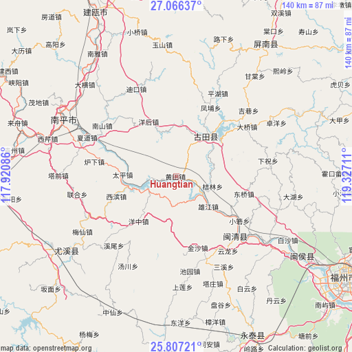
Huangtian GPS coordinates[2]
26° 26' 18.636" North, 118° 37' 26.328" East
| Map corner | latitude | longitude |
|---|---|---|
| Upper-left | 27.06637°, | 117.92086° |
| Center: | 26.43851°, | 118.62398° |
| Lower-right: | 25.80721°, | 119.32711° |
| Map W x H: | 140×140 km | = 87×87mi |
| max Lat: | 53.31946° ⇑80.7% North |
| Huangtian: | 26.43851° |
| min Lat: | ⇓19.3% South 18.22056° |
| min Long | Huangtian | max Long |
| 75.07348° | 118.62398° | 134.28917° |
| W 74%⇐ | ⇒26% E |
Elevation
Elevation of Huangtian is 124 m = 407 ft, and this is 360.8 m = 1184 ft below average elevation for this country.
| Max E: |
5622 m = 18445 ft | 56% |
| Avg. | 484.8 m = 1591 ft | |
| Huangtian | 124 m = 407 ft | |
Min E: |
-3 m = -10 ft | 44% |
See also: China elevation on elevation.city.
Geographical zone
Huangtian is located in North temperate zone (between Tropic of Cancer and the Arctic Circle). Distance of this Northern Tropic circle is 333.8 km =207.4 mi to South.| Distance of | km | miles | from Huangtian |
|---|---|---|---|
| North Pole | 7067.4 | 4391.5 | to North |
| Arctic Circle | 4461.5 | 2772.2 | to North |
| Tropic Cancer | 333.8 | 207.4 | to South |
| Equator | 2939.7 | 1826.6 | to South |


Nearby cities:
15 places around Huangtian: (largest is in red/bold)
• Chengdong
19.3 km =12 mi,  36°
36°
• Chimen
21.2 km =13.2 mi,  304°
304°
• Dongqiao
27.6 km =17.1 mi,  105°
105°
• Jielin
15 km =9.3 mi, 105°
• Jinsha
29.8 km =18.5 mi,  163°
163°
• Panyang
24 km =14.9 mi,  59°
59°
• Shuangzhu
21.5 km =13.4 mi,  5°
5°
• Shuikou
12.2 km =7.6 mi,  119°
119°
• Songji
19.2 km =11.9 mi, 37°
• Taiping
20.5 km =12.7 mi,  272°
272°
• Xibin
26 km =16.2 mi,  252°
252°
• Xiongjiang
16.5 km =10.3 mi,  134°
134°
• Yanghou
25.3 km =15.7 mi,  332°
332°
• Youxikou
18.5 km =11.5 mi,  255°
255°
• Zhanghuban
15.1 km =9.4 mi, 247°
Sources, notices
• [Note1] Compared only with cities in China existing in our database
• [Src1] Map data: © OpenStreetMap contributors (CC-BY-SA)
• [Src2] Other city data from geonames.org with taken over terms of usage.
• [Src3] Geographical zone / Annual Mean Temperature by Robert A. Rohde @ Wikipedia
