Qabqa geodata
Qabqa (Qinghai) is a seat of a third-order administrative division; located in China in Asia/Shanghai (GMT+8) time zone. In our database, there are 1268 cities with bigger population. Compared to other cities in China, 77.7% of cities are located further ↓South; 94.1% of cities are located further →East and 96.5% of cities have lower elevation than Qabqa. Note1


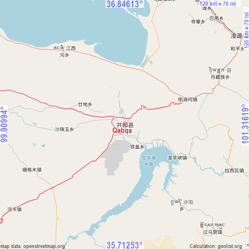
Qabqa GPS coordinates[2]
36° 16' 53.004" North, 100° 36' 47.016" East
| Map corner | latitude | longitude |
|---|---|---|
| Upper-left | 36.84613°, | 99.90994° |
| Center: | 36.28139°, | 100.61306° |
| Lower-right: | 35.71253°, | 101.31619° |
| Map W x H: | 126×126 km | = 78.3×78.3mi |
| max Lat: | 53.31946° ⇑22.3% North |
| Qabqa: | 36.28139° |
| min Lat: | ⇓77.7% South 18.22056° |
| min Long | Qabqa | max Long |
| 75.07348° | 100.61306° | 134.28917° |
| W 5.9%⇐ | ⇒94.1% E |
Elevation
Elevation of Qabqa is 2839 m = 9314 ft, and this is 2354.2 m = 7724 ft above average elevation for this country.
| Max E: |
5622 m = 18445 ft | 3.5% |
| Qabqa | 2839 m 9314 ft | |
| Avg. | 484.8 m = 1591 ft | |
Min E: |
-3 m = -10 ft | 96.5% |
See also: China elevation on elevation.city.
Geographical zone
Qabqa is located in North temperate zone (between Tropic of Cancer and the Arctic Circle). Distance of this Northern Tropic circle is 1428.2 km =887.4 mi to South.| Distance of | km | miles | from Qabqa |
|---|---|---|---|
| North Pole | 5972.9 | 3711.4 | to North |
| Arctic Circle | 3367.1 | 2092.2 | to North |
| Tropic Cancer | 1428.2 | 887.4 | to South |
| Equator | 4034.1 | 2506.7 | to South |


Nearby cities:
15 places around Qabqa: (largest is in red/bold)
• Daotanghe
34.1 km =21.2 mi,  67°
67°
• Gandi
26.2 km =16.3 mi,  300°
300°
• Heping
68.5 km =42.6 mi,  54°
54°
• Jiangxigou
49.9 km =31 mi,  321°
321°
• Lhakangtang
55.7 km =34.6 mi,  109°
109°
• Longyangxia
30.5 km =19 mi,  123°
123°
• Qinghaihu
64.6 km =40.1 mi,  16°
16°
• Riyue
56.2 km =34.9 mi,  59°
59°
• Sazhubxi
29.6 km =18.4 mi,  270°
270°
• Shagou
49.8 km =30.9 mi,  144°
144°
• Sizhai
63.2 km =39.3 mi,  35°
35°
• Tawan
63.6 km =39.5 mi, 44°
• Tiegai
13 km =8.1 mi,  147°
147°
• Tumba
17.8 km =11.1 mi, 52°
• Yingde’er
40.4 km =25.1 mi,  290°
290°
Sources, notices
• [Note1] Compared only with cities in China existing in our database
• [Src1] Map data: © OpenStreetMap contributors (CC-BY-SA)
• [Src2] Other city data from geonames.org with taken over terms of usage.
• [Src3] Geographical zone / Annual Mean Temperature by Robert A. Rohde @ Wikipedia
