Wuxi geodata
Wuxi (Hunan) is a seat of a third-order administrative division; located in China in Asia/Shanghai (GMT+8) time zone. With population of 66,442 people, there are 647 cities with bigger population in this country. Compared to other cities in China, 80.1% of cities are located further ↑North; 63.3% of cities are located further →East and 60.8% of cities have higher elevation than Wuxi. Note1


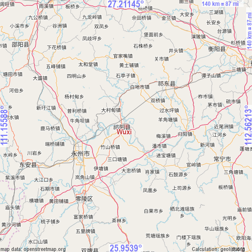
Wuxi GPS coordinates[2]
26° 35' 3.84" North, 111° 51' 32.4" East
| Map corner | latitude | longitude |
|---|---|---|
| Upper-left | 27.21145°, | 111.15588° |
| Center: | 26.5844°, | 111.859° |
| Lower-right: | 25.9539°, | 112.56213° |
| Map W x H: | 139.8×139.8 km | = 86.9×86.9mi |
| max Lat: | 53.31946° ⇑80.1% North |
| Wuxi: | 26.5844° |
| min Lat: | ⇓19.9% South 18.22056° |
| min Long | Wuxi | max Long |
| 75.07348° | 111.859° | 134.28917° |
| W 36.7%⇐ | ⇒63.3% E |
Elevation
Elevation of Wuxi is 94 m = 308 ft, and this is 390.8 m = 1282 ft below average elevation for this country.
| Max E: |
5622 m = 18445 ft | 60.8% |
| Avg. | 484.8 m = 1591 ft | |
| Wuxi | 94 m = 308 ft | |
Min E: |
-3 m = -10 ft | 39.2% |
See also: Wuxi elevation on elevation.city.
Geographical zone
Wuxi is located in North temperate zone (between Tropic of Cancer and the Arctic Circle). Distance of this Northern Tropic circle is 350 km =217.5 mi to South.| Distance of | km | miles | from Wuxi |
|---|---|---|---|
| North Pole | 7051.2 | 4381.4 | to North |
| Arctic Circle | 4445.3 | 2762.2 | to North |
| Tropic Cancer | 350 | 217.5 | to South |
| Equator | 2955.9 | 1836.7 | to South |


Nearby cities:
15 places around Wuxi: (largest is in red/bold)
• Baiyashi
63.3 km =39.3 mi,  249°
249°
• Bojia
17 km =10.6 mi,  140°
140°
• Hongqiao
32.1 km =19.9 mi,  50°
50°
• Huangtang
63.1 km =39.2 mi,  163°
163°
• Jicun
75.7 km =47 mi, 157°
• Lengshuijing
75.7 km =47 mi, 160°
• Lengshuitan
32.5 km =20.2 mi,  233°
233°
• Liangshi
70.2 km =43.6 mi,  350°
350°
• Longbo
76.6 km =47.6 mi,  197°
197°
• Majiang
68.3 km =42.4 mi,  181°
181°
• Menlouxia
72.3 km =44.9 mi,  151°
151°
• Tangdukou
74.6 km =46.4 mi,  304°
304°
• Tongmuluo
72.9 km =45.3 mi,  172°
172°
• Xidu
65.3 km =40.6 mi, 50°
• Yiyang
56.2 km =34.9 mi,  112°
112°
Sources, notices
• [Note1] Compared only with cities in China existing in our database
• [Src1] Map data: © OpenStreetMap contributors (CC-BY-SA)
• [Src2] Other city data from geonames.org with taken over terms of usage.
• [Src3] Geographical zone / Annual Mean Temperature by Robert A. Rohde @ Wikipedia
