Lengshuitan geodata
Lengshuitan (Hunan) is a populated place; located in China in Asia/Shanghai (GMT+8) time zone. With population of 88,935 people, there are 481 cities with bigger population in this country. Compared to other cities in China, 80.8% of cities are located further ↑North; 64.6% of cities are located further →East and 59.5% of cities have higher elevation than Lengshuitan. Note1


Lengshuitan GPS coordinates[2]
26° 24' 39.96" North, 111° 35' 44.124" East
| Map corner | latitude | longitude |
|---|---|---|
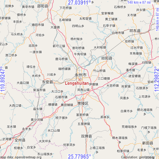
| Upper-left | 27.03911°, | 110.89247° |
| Center: | 26.4111°, | 111.59559° |
| Lower-right: | 25.77965°, | 112.29872° |
| Map W x H: | 140×140 km | = 87×87mi |
| max Lat: | 53.31946° ⇑80.8% North |
| Lengshuitan: | 26.4111° |
| min Lat: | ⇓19.2% South 18.22056° |
| min Long | Lengshuitan | max Long |
| 75.07348° | 111.59559° | 134.28917° |
| W 35.4%⇐ | ⇒64.6% E |
Elevation
Elevation of Lengshuitan is 101 m = 331 ft, and this is 383.8 m = 1259 ft below average elevation for this country.
| Max E: |
5622 m = 18445 ft | 59.5% |
| Avg. | 484.8 m = 1591 ft | |
| Lengshuitan | 101 m = 331 ft | |
Min E: |
-3 m = -10 ft | 40.5% |
See also: Lengshuitan elevation on elevation.city.
Geographical zone
Lengshuitan is located in North temperate zone (between Tropic of Cancer and the Arctic Circle). Distance of this Northern Tropic circle is 330.7 km =205.5 mi to South.| Distance of | km | miles | from Lengshuitan |
|---|---|---|---|
| North Pole | 7070.4 | 4393.3 | to North |
| Arctic Circle | 4464.5 | 2774.1 | to North |
| Tropic Cancer | 330.7 | 205.5 | to South |
| Equator | 2936.6 | 1824.7 | to South |


Nearby cities:
15 places around Lengshuitan: (largest is in red/bold)
• Baisha
67.3 km =41.8 mi,  280°
280°
• Baiyashi
33.3 km =20.7 mi,  265°
265°
• Bojia
37.6 km =23.4 mi,  80°
80°
• Hejiadong
59.1 km =36.7 mi,  189°
189°
• Hongqiao
64.6 km =40.1 mi,  52°
52°
• Huanglong
67.4 km =41.9 mi, 282°
• Huangtang
60.2 km =37.4 mi,  133°
133°
• Longbo
53.6 km =33.3 mi,  177°
177°
• Majiang
54.7 km =34 mi,  153°
153°
• Qingjiangqiao
64.4 km =40 mi,  289°
289°
• Shangrenli
57.8 km =35.9 mi, 175°
• Tangdukou
71 km =44.1 mi,  330°
330°
• Tongmuluo
63.8 km =39.6 mi, 146°
• Wuxi
32.5 km =20.2 mi, 53°
• Yongjiang
57.5 km =35.7 mi, 180°
Sources, notices
• [Note1] Compared only with cities in China existing in our database
• [Src1] Map data: © OpenStreetMap contributors (CC-BY-SA)
• [Src2] Other city data from geonames.org with taken over terms of usage.
• [Src3] Geographical zone / Annual Mean Temperature by Robert A. Rohde @ Wikipedia
