Bojia geodata
Bojia (Hunan) is a populated place; located in China in Asia/Shanghai (GMT+8) time zone. With population of 25,000 people, there are 804 cities with bigger population in this country. Compared to other cities in China, 80.6% of cities are located further ↑North; 62.9% of cities are located further →East and 61.7% of cities have higher elevation than Bojia. Note1


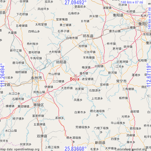
Bojia GPS coordinates[2]
26° 28' 1.992" North, 111° 58' 5.016" East
| Map corner | latitude | longitude |
|---|---|---|
| Upper-left | 27.09492°, | 111.26494° |
| Center: | 26.46722°, | 111.96806° |
| Lower-right: | 25.83608°, | 112.67119° |
| Map W x H: | 140×140 km | = 87×87mi |
| max Lat: | 53.31946° ⇑80.6% North |
| Bojia: | 26.46722° |
| min Lat: | ⇓19.4% South 18.22056° |
| min Long | Bojia | max Long |
| 75.07348° | 111.96806° | 134.28917° |
| W 37.1%⇐ | ⇒62.9% E |
Elevation
Elevation of Bojia is 89 m = 292 ft, and this is 395.8 m = 1299 ft below average elevation for this country.
| Max E: |
5622 m = 18445 ft | 61.7% |
| Avg. | 484.8 m = 1591 ft | |
| Bojia | 89 m = 292 ft | |
Min E: |
-3 m = -10 ft | 38.3% |
See also: China elevation on elevation.city.
Geographical zone
Bojia is located in North temperate zone (between Tropic of Cancer and the Arctic Circle). Distance of this Northern Tropic circle is 337 km =209.4 mi to South.| Distance of | km | miles | from Bojia |
|---|---|---|---|
| North Pole | 7064.2 | 4389.5 | to North |
| Arctic Circle | 4458.3 | 2770.3 | to North |
| Tropic Cancer | 337 | 209.4 | to South |
| Equator | 2942.9 | 1828.6 | to South |


Nearby cities:
15 places around Bojia: (largest is in red/bold)
• Hongqiao
36.3 km =22.6 mi,  22°
22°
• Huangtang
48 km =29.8 mi,  172°
172°
• Jicun
59.7 km =37.1 mi,  161°
161°
• Lengshuijing
60.1 km =37.3 mi, 166°
• Lengshuitan
37.6 km =23.4 mi,  260°
260°
• Lianhua
65.9 km =40.9 mi,  152°
152°
• Longbo
69.1 km =42.9 mi,  209°
209°
• Longquan
67.4 km =41.9 mi, 158°
• Majiang
56.7 km =35.2 mi,  193°
193°
• Maoli
70.3 km =43.7 mi, 165°
• Menlouxia
55.7 km =34.6 mi, 154°
• Tongmuluo
59.4 km =36.9 mi,  181°
181°
• Wuxi
17 km =10.6 mi,  320°
320°
• Xidu
67.4 km =41.9 mi,  36°
36°
• Yiyang
41.9 km =26 mi,  102°
102°
Sources, notices
• [Note1] Compared only with cities in China existing in our database
• [Src1] Map data: © OpenStreetMap contributors (CC-BY-SA)
• [Src2] Other city data from geonames.org with taken over terms of usage.
• [Src3] Geographical zone / Annual Mean Temperature by Robert A. Rohde @ Wikipedia
