Liangshi geodata
Liangshi (Hunan) is a seat of a third-order administrative division; located in China in Asia/Shanghai (GMT+8) time zone. In our database, there are 1268 cities with bigger population. Compared to other cities in China, 77.8% of cities are located further ↑North; 63.8% of cities are located further →East and 61.2% of cities have lower elevation than Liangshi. Note1


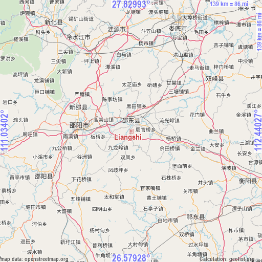
Liangshi GPS coordinates[2]
27° 12' 22.896" North, 111° 44' 13.704" East
| Map corner | latitude | longitude |
|---|---|---|
| Upper-left | 27.82993°, | 111.03402° |
| Center: | 27.20636°, | 111.73714° |
| Lower-right: | 26.57928°, | 112.44027° |
| Map W x H: | 139.1×139.1 km | = 86.4×86.4mi |
| max Lat: | 53.31946° ⇑77.8% North |
| Liangshi: | 27.20636° |
| min Lat: | ⇓22.2% South 18.22056° |
| min Long | Liangshi | max Long |
| 75.07348° | 111.73714° | 134.28917° |
| W 36.2%⇐ | ⇒63.8% E |
Elevation
Elevation of Liangshi is 274 m = 899 ft, and this is 210.8 m = 692 ft below average elevation for this country.
| Max E: |
5622 m = 18445 ft | 38.8% |
| Avg. | 484.8 m = 1591 ft | |
| Liangshi | 274 m = 899 ft | |
Min E: |
-3 m = -10 ft | 61.2% |
See also: China elevation on elevation.city.
Geographical zone
Liangshi is located in North temperate zone (between Tropic of Cancer and the Arctic Circle). Distance of this Northern Tropic circle is 419.1 km =260.4 mi to South.| Distance of | km | miles | from Liangshi |
|---|---|---|---|
| North Pole | 6982 | 4338.4 | to North |
| Arctic Circle | 4376.1 | 2719.2 | to North |
| Tropic Cancer | 419.1 | 260.4 | to South |
| Equator | 3025.1 | 1879.7 | to South |


Nearby cities:
15 places around Liangshi: (largest is in red/bold)
• Beishan
65.7 km =40.8 mi,  257°
257°
• Gaoping
66.1 km =41.1 mi,  297°
297°
• Hongqiao
61 km =37.9 mi,  142°
142°
• Lengshuijiang
61.6 km =38.3 mi,  330°
330°
• Lianyuan
54.1 km =33.6 mi,  352°
352°
• Loudi
64 km =39.8 mi,  23°
23°
• Niangxi
32.2 km =20 mi,  290°
290°
• Shimen
70 km =43.5 mi,  271°
271°
• Tangdukou
55.9 km =34.7 mi,  241°
241°
• Tantou
59 km =36.7 mi,  276°
276°
• Xidu
68.4 km =42.5 mi,  113°
113°
• Yankou
66.1 km =41.1 mi, 283°
• Yongfeng
50.5 km =31.4 mi,  60°
60°
• Yushanpu
62 km =38.5 mi, 264°
• Zhouwang
53.7 km =33.4 mi, 268°
Sources, notices
• [Note1] Compared only with cities in China existing in our database
• [Src1] Map data: © OpenStreetMap contributors (CC-BY-SA)
• [Src2] Other city data from geonames.org with taken over terms of usage.
• [Src3] Geographical zone / Annual Mean Temperature by Robert A. Rohde @ Wikipedia
