Hongqiao geodata
Hongqiao (Hunan) is a seat of a third-order administrative division; located in China in Asia/Shanghai (GMT+8) time zone. With population of 58,287 people, there are 756 cities with bigger population in this country. Compared to other cities in China, 79.5% of cities are located further ↑North; 62.2% of cities are located further →East and 55.9% of cities have higher elevation than Hongqiao. Note1


Hongqiao GPS coordinates[2]
26° 46' 6.132" North, 112° 6' 29.304" East
| Map corner | latitude | longitude |
|---|---|---|
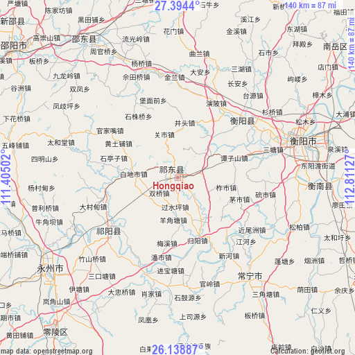
| Upper-left | 27.3944°, | 111.40502° |
| Center: | 26.76837°, | 112.10814° |
| Lower-right: | 26.13887°, | 112.81127° |
| Map W x H: | 139.6×139.6 km | = 86.7×86.7mi |
| max Lat: | 53.31946° ⇑79.5% North |
| Hongqiao: | 26.76837° |
| min Lat: | ⇓20.5% South 18.22056° |
| min Long | Hongqiao | max Long |
| 75.07348° | 112.10814° | 134.28917° |
| W 37.8%⇐ | ⇒62.2% E |
Elevation
Elevation of Hongqiao is 125 m = 410 ft, and this is 359.8 m = 1180 ft below average elevation for this country.
| Max E: |
5622 m = 18445 ft | 55.9% |
| Avg. | 484.8 m = 1591 ft | |
| Hongqiao | 125 m = 410 ft | |
Min E: |
-3 m = -10 ft | 44.1% |
See also: Hongqiao elevation on elevation.city.
Geographical zone
Hongqiao is located in North temperate zone (between Tropic of Cancer and the Arctic Circle). Distance of this Northern Tropic circle is 370.4 km =230.2 mi to South.| Distance of | km | miles | from Hongqiao |
|---|---|---|---|
| North Pole | 7030.7 | 4368.7 | to North |
| Arctic Circle | 4424.8 | 2749.4 | to North |
| Tropic Cancer | 370.4 | 230.2 | to South |
| Equator | 2976.4 | 1849.4 | to South |


Nearby cities:
15 places around Hongqiao: (largest is in red/bold)
• Bojia
36.3 km =22.6 mi,  202°
202°
• Hengyang
52.4 km =32.6 mi,  75°
75°
• Huangtang
81.4 km =50.6 mi,  185°
185°
• Kaiyun
89.1 km =55.4 mi,  56°
56°
• Leiyang
85 km =52.8 mi,  118°
118°
• Lengshuitan
64.6 km =40.1 mi,  232°
232°
• Liangshi
61 km =37.9 mi,  322°
322°
• Menlouxia
84.4 km =52.4 mi,  173°
173°
• Niangxi
90 km =55.9 mi,  311°
311°
• Tangdukou
88.7 km =55.1 mi,  284°
284°
• Wuxi
32.1 km =19.9 mi, 230°
• Xidu
33.2 km =20.6 mi,  51°
51°
• Yiyang
50.1 km =31.1 mi,  147°
147°
• Yongfeng
73.8 km =45.9 mi,  5°
5°
• Yunji
56.2 km =34.9 mi,  98°
98°
In other languages:
- In Russian: Хунцяо
- In Chinese: Hung-ch’iao-chen, Ch’i-tung, Hung-ch’iao-shih, Hung-ch’iao
Sources, notices
• [Note1] Compared only with cities in China existing in our database
• [Src1] Map data: © OpenStreetMap contributors (CC-BY-SA)
• [Src2] Other city data from geonames.org with taken over terms of usage.
• [Src3] Geographical zone / Annual Mean Temperature by Robert A. Rohde @ Wikipedia
