Qingfeng geodata
Qingfeng (Hubei) is a seat of a fourth-order administrative division; located in China in Asia/Shanghai (GMT+8) time zone. In our database, there are 1268 cities with bigger population. Compared to other cities in China, 61.4% of cities are located further ↓South; 67.1% of cities are located further →East and 64.3% of cities have lower elevation than Qingfeng. Note1


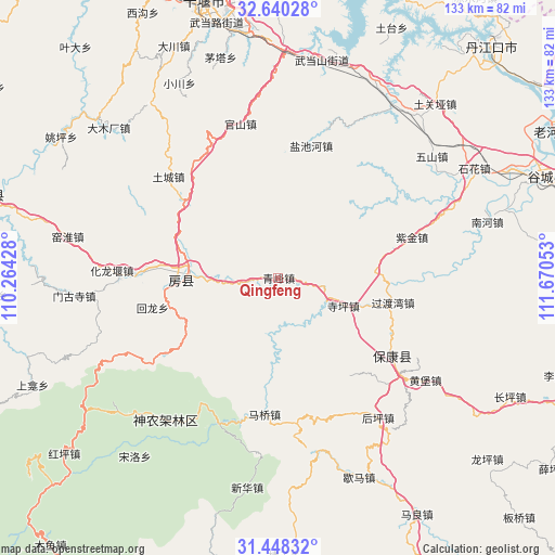
Qingfeng GPS coordinates[2]
32° 2' 46.464" North, 110° 58' 2.64" East
| Map corner | latitude | longitude |
|---|---|---|
| Upper-left | 32.64028°, | 110.26428° |
| Center: | 32.04624°, | 110.9674° |
| Lower-right: | 31.44832°, | 111.67053° |
| Map W x H: | 132.5×132.5 km | = 82.3×82.3mi |
| max Lat: | 53.31946° ⇑38.6% North |
| Qingfeng: | 32.04624° |
| min Lat: | ⇓61.4% South 18.22056° |
| min Long | Qingfeng | max Long |
| 75.07348° | 110.9674° | 134.28917° |
| W 32.9%⇐ | ⇒67.1% E |
Elevation
Elevation of Qingfeng is 314 m = 1030 ft, and this is 170.8 m = 560 ft below average elevation for this country.
| Max E: |
5622 m = 18445 ft | 35.7% |
| Avg. | 484.8 m = 1591 ft | |
| Qingfeng | 314 m = 1030 ft | |
Min E: |
-3 m = -10 ft | 64.3% |
See also: China elevation on elevation.city.
Geographical zone
Qingfeng is located in North temperate zone (between Tropic of Cancer and the Arctic Circle). Distance of this Northern Tropic circle is 957.3 km =594.8 mi to South.| Distance of | km | miles | from Qingfeng |
|---|---|---|---|
| North Pole | 6443.9 | 4004.1 | to North |
| Arctic Circle | 3838 | 2384.8 | to North |
| Tropic Cancer | 957.3 | 594.8 | to South |
| Equator | 3563.2 | 2214.1 | to South |


Nearby cities:
15 places around Qingfeng: (largest is in red/bold)
• Baokang Chengguanzhen
33.1 km =20.6 mi,  124°
124°
• Fangxian Chengguanzhen
22 km =13.7 mi,  272°
272°
• Guanshan
37.7 km =23.4 mi,  344°
344°
• Guoduwan
28 km =17.4 mi,  102°
102°
• Houping
41.3 km =25.7 mi,  144°
144°
• Hualongyan
40 km =24.9 mi, 272°
• Huangbao
42.7 km =26.5 mi, 124°
• Jundian
33 km =20.5 mi, 272°
• Maqiao
32.7 km =20.3 mi,  185°
185°
• Siping
16.9 km =10.5 mi,  113°
113°
• Songbai
42.5 km =26.4 mi,  220°
220°
• Tucheng
35.7 km =22.2 mi,  312°
312°
• Yanchihe
32.4 km =20.1 mi,  14°
14°
• Yangri
37 km =23 mi,  202°
202°
• Zijin
33.4 km =20.8 mi,  72°
72°
Sources, notices
• [Note1] Compared only with cities in China existing in our database
• [Src1] Map data: © OpenStreetMap contributors (CC-BY-SA)
• [Src2] Other city data from geonames.org with taken over terms of usage.
• [Src3] Geographical zone / Annual Mean Temperature by Robert A. Rohde @ Wikipedia
