Hualongyan geodata
Hualongyan (Hubei) is a seat of a fourth-order administrative division; located in China in Asia/Shanghai (GMT+8) time zone. In our database, there are 1268 cities with bigger population. Compared to other cities in China, 61.6% of cities are located further ↓South; 68.9% of cities are located further →East and 73.8% of cities have lower elevation than Hualongyan. Note1


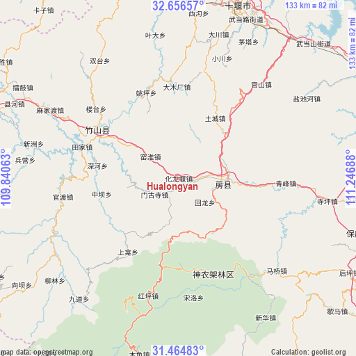
Hualongyan GPS coordinates[2]
32° 3' 45.504" North, 110° 32' 37.5" East
| Map corner | latitude | longitude |
|---|---|---|
| Upper-left | 32.65657°, | 109.84063° |
| Center: | 32.06264°, | 110.54375° |
| Lower-right: | 31.46483°, | 111.24688° |
| Map W x H: | 132.5×132.5 km | = 82.3×82.3mi |
| max Lat: | 53.31946° ⇑38.4% North |
| Hualongyan: | 32.06264° |
| min Lat: | ⇓61.6% South 18.22056° |
| min Long | Hualongyan | max Long |
| 75.07348° | 110.54375° | 134.28917° |
| W 31.1%⇐ | ⇒68.9% E |
Elevation
Elevation of Hualongyan is 496 m = 1627 ft, and this is 11.2 m = 37 ft above average elevation for this country.
| Max E: |
5622 m = 18445 ft | 26.2% |
| Hualongyan | 496 m 1627 ft | |
| Avg. | 484.8 m = 1591 ft | |
Min E: |
-3 m = -10 ft | 73.8% |
See also: China elevation on elevation.city.
Geographical zone
Hualongyan is located in North temperate zone (between Tropic of Cancer and the Arctic Circle). Distance of this Northern Tropic circle is 959.1 km =596 mi to South.| Distance of | km | miles | from Hualongyan |
|---|---|---|---|
| North Pole | 6442 | 4002.9 | to North |
| Arctic Circle | 3836.1 | 2383.6 | to North |
| Tropic Cancer | 959.1 | 596 | to South |
| Equator | 3565 | 2215.2 | to South |


Nearby cities:
15 places around Hualongyan: (largest is in red/bold)
• Fangxian Chengguanzhen
18 km =11.2 mi,  92°
92°
• Guandu
44.4 km =27.6 mi,  260°
260°
• Guanshan
45.7 km =28.4 mi,  40°
40°
• Hongping
45.2 km =28.1 mi,  194°
194°
• Jundian
7 km =4.3 mi, 94°
• Maqiao
50.2 km =31.2 mi,  133°
133°
• Mengusi
10.7 km =6.6 mi,  235°
235°
• Qingfeng
40 km =24.9 mi, 92°
• Songbai
36.1 km =22.4 mi,  160°
160°
• Tianjiaba
39.5 km =24.5 mi,  287°
287°
• Tucheng
26.2 km =16.3 mi,  31°
31°
• Yangri
44.1 km =27.4 mi,  144°
144°
• Yeda
54 km =33.6 mi,  350°
350°
• Yishui
48.4 km =30.1 mi,  298°
298°
• Zhushan Chengguanzhen
33.9 km =21.1 mi, 301°
Sources, notices
• [Note1] Compared only with cities in China existing in our database
• [Src1] Map data: © OpenStreetMap contributors (CC-BY-SA)
• [Src2] Other city data from geonames.org with taken over terms of usage.
• [Src3] Geographical zone / Annual Mean Temperature by Robert A. Rohde @ Wikipedia
