Jundian geodata
Jundian (Hubei) is a seat of a fourth-order administrative division; located in China in Asia/Shanghai (GMT+8) time zone. In our database, there are 1268 cities with bigger population. Compared to other cities in China, 61.5% of cities are located further ↓South; 68.6% of cities are located further →East and 72.7% of cities have lower elevation than Jundian. Note1


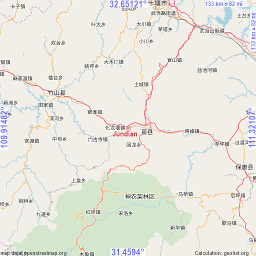
Jundian GPS coordinates[2]
32° 3' 26.1" North, 110° 37' 4.584" East
| Map corner | latitude | longitude |
|---|---|---|
| Upper-left | 32.65121°, | 109.91482° |
| Center: | 32.05725°, | 110.61794° |
| Lower-right: | 31.4594°, | 111.32107° |
| Map W x H: | 132.5×132.5 km | = 82.3×82.3mi |
| max Lat: | 53.31946° ⇑38.5% North |
| Jundian: | 32.05725° |
| min Lat: | ⇓61.5% South 18.22056° |
| min Long | Jundian | max Long |
| 75.07348° | 110.61794° | 134.28917° |
| W 31.4%⇐ | ⇒68.6% E |
Elevation
Elevation of Jundian is 467 m = 1532 ft, and this is 17.8 m = 58 ft below average elevation for this country.
| Max E: |
5622 m = 18445 ft | 27.3% |
| Avg. | 484.8 m = 1591 ft | |
| Jundian | 467 m = 1532 ft | |
Min E: |
-3 m = -10 ft | 72.7% |
See also: China elevation on elevation.city.
Geographical zone
Jundian is located in North temperate zone (between Tropic of Cancer and the Arctic Circle). Distance of this Northern Tropic circle is 958.5 km =595.6 mi to South.| Distance of | km | miles | from Jundian |
|---|---|---|---|
| North Pole | 6442.6 | 4003.2 | to North |
| Arctic Circle | 3836.7 | 2384 | to North |
| Tropic Cancer | 958.5 | 595.6 | to South |
| Equator | 3564.4 | 2214.8 | to South |


Nearby cities:
15 places around Jundian: (largest is in red/bold)
• Fangxian Chengguanzhen
11 km =6.8 mi,  91°
91°
• Guandu
51.2 km =31.8 mi,  262°
262°
• Guanshan
42 km =26.1 mi,  33°
33°
• Hongping
46.9 km =29.1 mi,  202°
202°
• Hualongyan
7 km =4.3 mi,  274°
274°
• Maqiao
44.9 km =27.9 mi,  138°
138°
• Mengusi
16.7 km =10.4 mi,  251°
251°
• Qingfeng
33 km =20.5 mi, 92°
• Siping
49.1 km =30.5 mi,  99°
99°
• Songbai
33.8 km =21 mi,  171°
171°
• Tianjiaba
46.3 km =28.8 mi,  285°
285°
• Tucheng
23.9 km =14.9 mi,  16°
16°
• Yanchihe
50.7 km =31.5 mi,  53°
53°
• Yangri
39.9 km =24.8 mi,  152°
152°
• Zhushan Chengguanzhen
40.3 km =25 mi,  296°
296°
Sources, notices
• [Note1] Compared only with cities in China existing in our database
• [Src1] Map data: © OpenStreetMap contributors (CC-BY-SA)
• [Src2] Other city data from geonames.org with taken over terms of usage.
• [Src3] Geographical zone / Annual Mean Temperature by Robert A. Rohde @ Wikipedia
