Jiangxigou geodata
Jiangxigou (Qinghai) is a seat of a fourth-order administrative division; located in China in Asia/Shanghai (GMT+8) time zone. In our database, there are 1268 cities with bigger population. Compared to other cities in China, 78.4% of cities are located further ↓South; 94.3% of cities are located further →East and 97.2% of cities have lower elevation than Jiangxigou. Note1


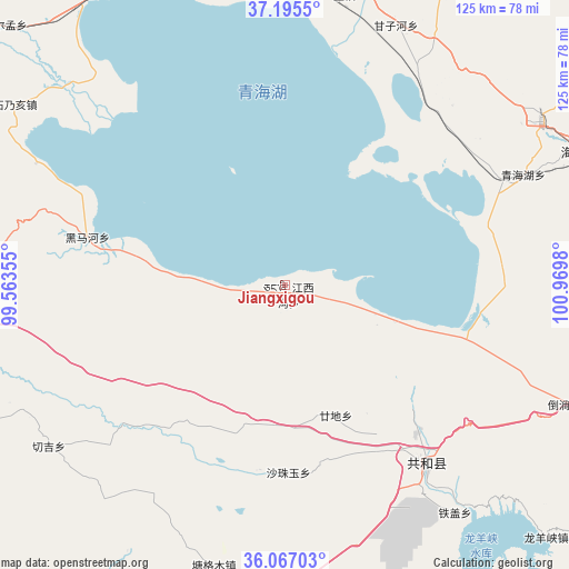
Jiangxigou GPS coordinates[2]
36° 37' 59.988" North, 100° 16' 0.012" East
| Map corner | latitude | longitude |
|---|---|---|
| Upper-left | 37.1955°, | 99.56355° |
| Center: | 36.63333°, | 100.26667° |
| Lower-right: | 36.06703°, | 100.9698° |
| Map W x H: | 125.5×125.5 km | = 78×78mi |
| max Lat: | 53.31946° ⇑21.6% North |
| Jiangxigou: | 36.63333° |
| min Lat: | ⇓78.4% South 18.22056° |
| min Long | Jiangxigou | max Long |
| 75.07348° | 100.26667° | 134.28917° |
| W 5.7%⇐ | ⇒94.3% E |
Elevation
Elevation of Jiangxigou is 3221 m = 10568 ft, and this is 2736.2 m = 8977 ft above average elevation for this country.
| Max E: |
5622 m = 18445 ft | 2.8% |
| Jiangxigou | 3221 m 10568 ft | |
| Avg. | 484.8 m = 1591 ft | |
Min E: |
-3 m = -10 ft | 97.2% |
See also: China elevation on elevation.city.
Geographical zone
Jiangxigou is located in North temperate zone (between Tropic of Cancer and the Arctic Circle). Distance of this Northern Tropic circle is 1467.3 km =911.7 mi to South.| Distance of | km | miles | from Jiangxigou |
|---|---|---|---|
| North Pole | 5933.8 | 3687.1 | to North |
| Arctic Circle | 3327.9 | 2067.9 | to North |
| Tropic Cancer | 1467.3 | 911.7 | to South |
| Equator | 4073.2 | 2531 | to South |


Nearby cities:
15 places around Jiangxigou: (largest is in red/bold)
• Daotanghe
67.7 km =42.1 mi,  112°
112°
• Dongke
63.1 km =39.2 mi,  238°
238°
• Gandi
27.3 km =17 mi,  162°
162°
• Hairag
66.9 km =41.6 mi,  11°
11°
• Heimahe
45 km =28 mi,  283°
283°
• Qabqa
49.9 km =31 mi,  141°
141°
• Qinghaihu
54.4 km =33.8 mi,  65°
65°
• Sanjiaocheng
71.3 km =44.3 mi, 66°
• Sazhubxi
38.9 km =24.2 mi,  177°
177°
• Shinaihai
68.8 km =42.8 mi,  304°
304°
• Sizhai
68.9 km =42.8 mi,  79°
79°
• Tiegai
62.9 km =39.1 mi, 142°
• Tumba
53.1 km =33 mi,  122°
122°
• Tuohua
62.1 km =38.6 mi,  36°
36°
• Yingde’er
26.2 km =16.3 mi,  195°
195°
Sources, notices
• [Note1] Compared only with cities in China existing in our database
• [Src1] Map data: © OpenStreetMap contributors (CC-BY-SA)
• [Src2] Other city data from geonames.org with taken over terms of usage.
• [Src3] Geographical zone / Annual Mean Temperature by Robert A. Rohde @ Wikipedia
