Sazhubxi geodata
Sazhubxi (Qinghai) is a seat of a fourth-order administrative division; located in China in Asia/Shanghai (GMT+8) time zone. In our database, there are 1268 cities with bigger population. Compared to other cities in China, 77.8% of cities are located further ↓South; 94.3% of cities are located further →East and 96.7% of cities have lower elevation than Sazhubxi. Note1


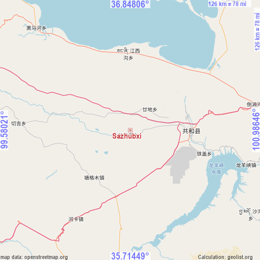
Sazhubxi GPS coordinates[2]
36° 16' 59.988" North, 100° 16' 59.988" East
| Map corner | latitude | longitude |
|---|---|---|
| Upper-left | 36.84806°, | 99.58021° |
| Center: | 36.28333°, | 100.28333° |
| Lower-right: | 35.71449°, | 100.98646° |
| Map W x H: | 126×126 km | = 78.3×78.3mi |
| max Lat: | 53.31946° ⇑22.2% North |
| Sazhubxi: | 36.28333° |
| min Lat: | ⇓77.8% South 18.22056° |
| min Long | Sazhubxi | max Long |
| 75.07348° | 100.28333° | 134.28917° |
| W 5.7%⇐ | ⇒94.3% E |
Elevation
Elevation of Sazhubxi is 2912 m = 9554 ft, and this is 2427.2 m = 7963 ft above average elevation for this country.
| Max E: |
5622 m = 18445 ft | 3.3% |
| Sazhubxi | 2912 m 9554 ft | |
| Avg. | 484.8 m = 1591 ft | |
Min E: |
-3 m = -10 ft | 96.7% |
See also: China elevation on elevation.city.
Geographical zone
Sazhubxi is located in North temperate zone (between Tropic of Cancer and the Arctic Circle). Distance of this Northern Tropic circle is 1428.4 km =887.6 mi to South.| Distance of | km | miles | from Sazhubxi |
|---|---|---|---|
| North Pole | 5972.7 | 3711.3 | to North |
| Arctic Circle | 3366.8 | 2092 | to North |
| Tropic Cancer | 1428.4 | 887.6 | to South |
| Equator | 4034.3 | 2506.8 | to South |


Nearby cities:
15 places around Sazhubxi: (largest is in red/bold)
• Daotanghe
62.4 km =38.8 mi,  78°
78°
• Dongke
55.5 km =34.5 mi,  275°
275°
• Gandi
14.7 km =9.1 mi,  28°
28°
• Heimahe
67.1 km =41.7 mi,  317°
317°
• Heka
51 km =31.7 mi,  211°
211°
• Jiangxigou
38.9 km =24.2 mi,  357°
357°
• Longyangxia
57.5 km =35.7 mi,  107°
107°
• Qabqa
29.6 km =18.4 mi,  90°
90°
• Qinghaihu
78.2 km =48.6 mi,  37°
37°
• Quedantang
75.9 km =47.2 mi,  157°
157°
• Shagou
71.4 km =44.4 mi,  124°
124°
• Taxiu
77.5 km =48.2 mi,  169°
169°
• Tiegai
38.3 km =23.8 mi, 106°
• Tumba
44.9 km =27.9 mi, 76°
• Yingde’er
16.1 km =10 mi,  328°
328°
Sources, notices
• [Note1] Compared only with cities in China existing in our database
• [Src1] Map data: © OpenStreetMap contributors (CC-BY-SA)
• [Src2] Other city data from geonames.org with taken over terms of usage.
• [Src3] Geographical zone / Annual Mean Temperature by Robert A. Rohde @ Wikipedia
