Shensuo geodata
Shensuo (Guangdong) is a seat of a fourth-order administrative division; located in China in Asia/Shanghai (GMT+8) time zone. In our database, there are 1268 cities with bigger population. Compared to other cities in China, 86.7% of cities are located further ↑North; 51.5% of cities are located further →East and 53.5% of cities have higher elevation than Shensuo. Note1


Shensuo GPS coordinates[2]
24° 55' 15.924" North, 113° 58' 35.256" East
| Map corner | latitude | longitude |
|---|---|---|
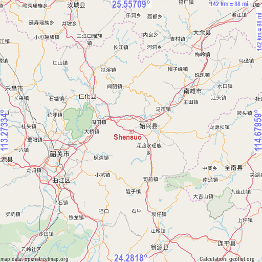
| Upper-left | 25.55709°, | 113.27334° |
| Center: | 24.92109°, | 113.97646° |
| Lower-right: | 24.2818°, | 114.67959° |
| Map W x H: | 141.8×141.8 km | = 88.1×88.1mi |
| max Lat: | 53.31946° ⇑86.7% North |
| Shensuo: | 24.92109° |
| min Lat: | ⇓13.3% South 18.22056° |
| min Long | Shensuo | max Long |
| 75.07348° | 113.97646° | 134.28917° |
| W 48.5%⇐ | ⇒51.5% E |
Elevation
Elevation of Shensuo is 140 m = 459 ft, and this is 344.8 m = 1131 ft below average elevation for this country.
| Max E: |
5622 m = 18445 ft | 53.5% |
| Avg. | 484.8 m = 1591 ft | |
| Shensuo | 140 m = 459 ft | |
Min E: |
-3 m = -10 ft | 46.5% |
See also: China elevation on elevation.city.
Geographical zone
Shensuo is located in North temperate zone (between Tropic of Cancer and the Arctic Circle). Distance of this Northern Tropic circle is 165 km =102.5 mi to South.| Distance of | km | miles | from Shensuo |
|---|---|---|---|
| North Pole | 7236.1 | 4496.3 | to North |
| Arctic Circle | 4630.2 | 2877.1 | to North |
| Tropic Cancer | 165 | 102.5 | to South |
| Equator | 2771 | 1721.8 | to South |


Nearby cities:
15 places around Shensuo: (largest is in red/bold)
• Chengnan
8 km =5 mi,  84°
84°
• Danxia
26.9 km =16.7 mi,  301°
301°
• Daqiao
22.3 km =13.9 mi,  267°
267°
• Dungang
15.5 km =9.6 mi,  91°
91°
• Fengwan
21.6 km =13.4 mi,  231°
231°
• Huangkeng
22 km =13.7 mi,  313°
313°
• Luoba
24.4 km =15.2 mi,  104°
104°
• Mashi
21.1 km =13.1 mi,  55°
55°
• Renhua
30.1 km =18.7 mi, 308°
• Shendushui
15.9 km =9.9 mi,  134°
134°
• Shixing
9.5 km =5.9 mi,  71°
71°
• Taiping
9.2 km =5.7 mi, 70°
• Wenshao
26.1 km =16.2 mi,  339°
339°
• Xiaokeng
28 km =17.4 mi,  215°
215°
• Zhoutian
17.6 km =10.9 mi,  286°
286°
Sources, notices
• [Note1] Compared only with cities in China existing in our database
• [Src1] Map data: © OpenStreetMap contributors (CC-BY-SA)
• [Src2] Other city data from geonames.org with taken over terms of usage.
• [Src3] Geographical zone / Annual Mean Temperature by Robert A. Rohde @ Wikipedia
