Luorong geodata
Luorong (Guangxi) is a populated place; located in China in Asia/Shanghai (GMT+8) time zone. With population of 67,593 people, there are 635 cities with bigger population in this country. Compared to other cities in China, 88.8% of cities are located further ↑North; 73.3% of cities are located further →East and 64.3% of cities have higher elevation than Luorong. Note1


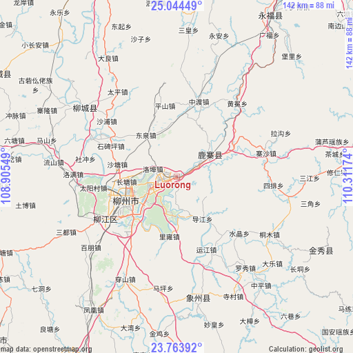
Luorong GPS coordinates[2]
24° 24' 20.988" North, 109° 36' 30.996" East
| Map corner | latitude | longitude |
|---|---|---|
| Upper-left | 25.04449°, | 108.90549° |
| Center: | 24.40583°, | 109.60861° |
| Lower-right: | 23.76392°, | 110.31174° |
| Map W x H: | 142.4×142.4 km | = 88.5×88.5mi |
| max Lat: | 53.31946° ⇑88.8% North |
| Luorong: | 24.40583° |
| min Lat: | ⇓11.2% South 18.22056° |
| min Long | Luorong | max Long |
| 75.07348° | 109.60861° | 134.28917° |
| W 26.7%⇐ | ⇒73.3% E |
Elevation
Elevation of Luorong is 76 m = 249 ft, and this is 408.8 m = 1341 ft below average elevation for this country.
| Max E: |
5622 m = 18445 ft | 64.3% |
| Avg. | 484.8 m = 1591 ft | |
| Luorong | 76 m = 249 ft | |
Min E: |
-3 m = -10 ft | 35.7% |
See also: Luorong elevation on elevation.city.
Geographical zone
Luorong is located in North temperate zone (between Tropic of Cancer and the Arctic Circle). Distance of this Northern Tropic circle is 107.8 km =67 mi to South.| Distance of | km | miles | from Luorong |
|---|---|---|---|
| North Pole | 7293.4 | 4531.9 | to North |
| Arctic Circle | 4687.5 | 2912.7 | to North |
| Tropic Cancer | 107.8 | 67 | to South |
| Equator | 2713.7 | 1686.2 | to South |


Nearby cities:
15 places around Luorong: (largest is in red/bold)
• Dabu
47.6 km =29.6 mi,  307°
307°
• Dongmen
83.5 km =51.9 mi,  300°
300°
• Jinxiu
65.2 km =40.5 mi,  117°
117°
• Labu
32.2 km =20 mi,  239°
239°
• Laibin
85.8 km =53.3 mi,  203°
203°
• Licheng
79.8 km =49.6 mi,  81°
81°
• Liuzhou
24.5 km =15.2 mi, 244°
• Luzhai
16.2 km =10.1 mi,  51°
51°
• Mengshan
94.6 km =58.8 mi,  103°
103°
• Rongshui
81.9 km =50.9 mi,  333°
333°
• Rong’an
94.8 km =58.9 mi,  346°
346°
• Wuxuan
87 km =54.1 mi,  177°
177°
• Xiangzhou
48.5 km =30.1 mi,  173°
173°
• Yangshuo
98.4 km =61.1 mi,  64°
64°
• Yongfu
76.5 km =47.5 mi,  29°
29°
Sources, notices
• [Note1] Compared only with cities in China existing in our database
• [Src1] Map data: © OpenStreetMap contributors (CC-BY-SA)
• [Src2] Other city data from geonames.org with taken over terms of usage.
• [Src3] Geographical zone / Annual Mean Temperature by Robert A. Rohde @ Wikipedia
