Labu geodata
Labu (Guangxi) is a seat of a third-order administrative division; located in China in Asia/Shanghai (GMT+8) time zone. In our database, there are 1268 cities with bigger population. Compared to other cities in China, 89.4% of cities are located further ↑North; 74.7% of cities are located further →East and 58.4% of cities have higher elevation than Labu. Note1


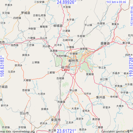
Labu GPS coordinates[2]
24° 15' 35.46" North, 109° 20' 2.94" East
| Map corner | latitude | longitude |
|---|---|---|
| Upper-left | 24.89926°, | 108.63103° |
| Center: | 24.25985°, | 109.33415° |
| Lower-right: | 23.61721°, | 110.03728° |
| Map W x H: | 142.6×142.6 km | = 88.6×88.6mi |
| max Lat: | 53.31946° ⇑89.4% North |
| Labu: | 24.25985° |
| min Lat: | ⇓10.6% South 18.22056° |
| min Long | Labu | max Long |
| 75.07348° | 109.33415° | 134.28917° |
| W 25.3%⇐ | ⇒74.7% E |
Elevation
Elevation of Labu is 109 m = 358 ft, and this is 375.8 m = 1233 ft below average elevation for this country.
| Max E: |
5622 m = 18445 ft | 58.4% |
| Avg. | 484.8 m = 1591 ft | |
| Labu | 109 m = 358 ft | |
Min E: |
-3 m = -10 ft | 41.6% |
See also: China elevation on elevation.city.
Geographical zone
Labu is located in North temperate zone (between Tropic of Cancer and the Arctic Circle). Distance of this Northern Tropic circle is 91.5 km =56.9 mi to South.| Distance of | km | miles | from Labu |
|---|---|---|---|
| North Pole | 7309.6 | 4542 | to North |
| Arctic Circle | 4703.7 | 2922.7 | to North |
| Tropic Cancer | 91.5 | 56.9 | to South |
| Equator | 2697.4 | 1676.1 | to South |


Nearby cities:
15 places around Labu: (largest is in red/bold)
• Dabu
46.4 km =28.8 mi,  347°
347°
• Dafeng
118.4 km =73.6 mi,  219°
219°
• Dongmen
73.7 km =45.8 mi,  323°
323°
• Jinxiu
86.9 km =54 mi,  99°
99°
• Laibin
62.6 km =38.9 mi,  186°
186°
• Licheng
110.3 km =68.5 mi,  75°
75°
• Liuzhou
8.1 km =5 mi,  43°
43°
• Luorong
32.2 km =20 mi,  59°
59°
• Luzhai
48.3 km =30 mi, 56°
• Rongshui
90.1 km =56 mi, 354°
• Rong’an
108.4 km =67.4 mi,  2°
2°
• Wuxuan
77.7 km =48.3 mi,  155°
155°
• Xiangzhou
46.5 km =28.9 mi,  133°
133°
• Xincheng Chengguanzhen
71.8 km =44.6 mi,  254°
254°
• Yongfu
105.5 km =65.6 mi, 38°
Sources, notices
• [Note1] Compared only with cities in China existing in our database
• [Src1] Map data: © OpenStreetMap contributors (CC-BY-SA)
• [Src2] Other city data from geonames.org with taken over terms of usage.
• [Src3] Geographical zone / Annual Mean Temperature by Robert A. Rohde @ Wikipedia
