Dongmen geodata
Dongmen (Guangxi) is a seat of a third-order administrative division; located in China in Asia/Shanghai (GMT+8) time zone. In our database, there are 1268 cities with bigger population. Compared to other cities in China, 87.2% of cities are located further ↑North; 76.8% of cities are located further →East and 66.3% of cities have lower elevation than Dongmen. Note1


Dongmen GPS coordinates[2]
24° 47' 31.128" North, 108° 54' 0" East
| Map corner | latitude | longitude |
|---|---|---|
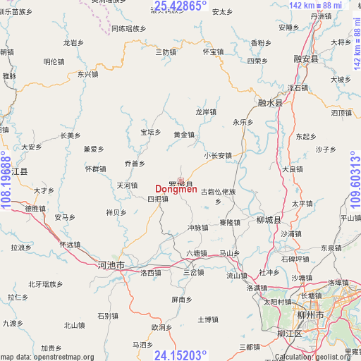
| Upper-left | 25.42865°, | 108.19688° |
| Center: | 24.79198°, | 108.9° |
| Lower-right: | 24.15203°, | 109.60313° |
| Map W x H: | 141.9×141.9 km | = 88.2×88.2mi |
| max Lat: | 53.31946° ⇑87.2% North |
| Dongmen: | 24.79198° |
| min Lat: | ⇓12.8% South 18.22056° |
| min Long | Dongmen | max Long |
| 75.07348° | 108.9° | 134.28917° |
| W 23.2%⇐ | ⇒76.8% E |
Elevation
Elevation of Dongmen is 348 m = 1142 ft, and this is 136.8 m = 449 ft below average elevation for this country.
| Max E: |
5622 m = 18445 ft | 33.7% |
| Avg. | 484.8 m = 1591 ft | |
| Dongmen | 348 m = 1142 ft | |
Min E: |
-3 m = -10 ft | 66.3% |
See also: China elevation on elevation.city.
Geographical zone
Dongmen is located in North temperate zone (between Tropic of Cancer and the Arctic Circle). Distance of this Northern Tropic circle is 150.7 km =93.6 mi to South.| Distance of | km | miles | from Dongmen |
|---|---|---|---|
| North Pole | 7250.5 | 4505.3 | to North |
| Arctic Circle | 4644.6 | 2886 | to North |
| Tropic Cancer | 150.7 | 93.6 | to South |
| Equator | 2756.6 | 1712.9 | to South |


Nearby cities:
15 places around Dongmen: (largest is in red/bold)
• Chuanshan
87.8 km =54.6 mi,  290°
290°
• Dabu
36.6 km =22.7 mi,  112°
112°
• Darong
110.5 km =68.7 mi,  358°
358°
• Gaowu
85.7 km =53.3 mi,  0°
0°
• Labu
73.7 km =45.8 mi,  143°
143°
• Liuzhou
72.7 km =45.2 mi, 137°
• Luorong
83.5 km =51.9 mi,  120°
120°
• Luzhai
90.3 km =56.1 mi, 111°
• Maolan
106.3 km =66.1 mi,  308°
308°
• Rongshui
46.7 km =29 mi,  49°
49°
• Rong’an
69.1 km =42.9 mi,  44°
44°
• Si’en
63.7 km =39.6 mi,  275°
275°
• Xiajiang
109.2 km =67.9 mi,  348°
348°
• Xincheng Chengguanzhen
82.4 km =51.2 mi,  197°
197°
• Xishan
99.5 km =61.8 mi, 3°
Sources, notices
• [Note1] Compared only with cities in China existing in our database
• [Src1] Map data: © OpenStreetMap contributors (CC-BY-SA)
• [Src2] Other city data from geonames.org with taken over terms of usage.
• [Src3] Geographical zone / Annual Mean Temperature by Robert A. Rohde @ Wikipedia
