Dabu geodata
Dabu (Guangxi) is a seat of a third-order administrative division; located in China in Asia/Shanghai (GMT+8) time zone. In our database, there are 1268 cities with bigger population. Compared to other cities in China, 87.8% of cities are located further ↑North; 75.2% of cities are located further →East and 59.7% of cities have higher elevation than Dabu. Note1


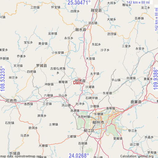
Dabu GPS coordinates[2]
24° 40' 2.604" North, 109° 14' 7.692" East
| Map corner | latitude | longitude |
|---|---|---|
| Upper-left | 25.30471°, | 108.53235° |
| Center: | 24.66739°, | 109.23547° |
| Lower-right: | 24.0268°, | 109.9386° |
| Map W x H: | 142.1×142.1 km | = 88.3×88.3mi |
| max Lat: | 53.31946° ⇑87.8% North |
| Dabu: | 24.66739° |
| min Lat: | ⇓12.2% South 18.22056° |
| min Long | Dabu | max Long |
| 75.07348° | 109.23547° | 134.28917° |
| W 24.8%⇐ | ⇒75.2% E |
Elevation
Elevation of Dabu is 100 m = 328 ft, and this is 384.8 m = 1262 ft below average elevation for this country.
| Max E: |
5622 m = 18445 ft | 59.7% |
| Avg. | 484.8 m = 1591 ft | |
| Dabu | 100 m = 328 ft | |
Min E: |
-3 m = -10 ft | 40.3% |
See also: China elevation on elevation.city.
Geographical zone
Dabu is located in North temperate zone (between Tropic of Cancer and the Arctic Circle). Distance of this Northern Tropic circle is 136.8 km =85 mi to South.| Distance of | km | miles | from Dabu |
|---|---|---|---|
| North Pole | 7264.3 | 4513.8 | to North |
| Arctic Circle | 4658.4 | 2894.6 | to North |
| Tropic Cancer | 136.8 | 85 | to South |
| Equator | 2742.8 | 1704.3 | to South |


Nearby cities:
15 places around Dabu: (largest is in red/bold)
• Dongmen
36.6 km =22.7 mi,  292°
292°
• Gaowu
104.8 km =65.1 mi,  341°
341°
• Jinxiu
112.4 km =69.8 mi,  121°
121°
• Labu
46.4 km =28.8 mi,  167°
167°
• Laibin
107.6 km =66.9 mi,  178°
178°
• Liuzhou
42.4 km =26.3 mi,  158°
158°
• Luorong
47.6 km =29.6 mi,  127°
127°
• Luzhai
53.7 km =33.4 mi,  110°
110°
• Rongshui
44.4 km =27.6 mi,  1°
1°
• Rong’an
64.7 km =40.2 mi,  13°
13°
• Si’en
99.2 km =61.6 mi,  281°
281°
• Xiangzhou
88.7 km =55.1 mi,  150°
150°
• Xincheng Chengguanzhen
87.5 km =54.4 mi,  222°
222°
• Xishan
116.4 km =72.3 mi,  346°
346°
• Yongfu
84.1 km =52.3 mi,  63°
63°
Sources, notices
• [Note1] Compared only with cities in China existing in our database
• [Src1] Map data: © OpenStreetMap contributors (CC-BY-SA)
• [Src2] Other city data from geonames.org with taken over terms of usage.
• [Src3] Geographical zone / Annual Mean Temperature by Robert A. Rohde @ Wikipedia
