Longtan geodata
Longtan (Hunan) is a populated place; located in China in Asia/Shanghai (GMT+8) time zone. With population of 2,800 people, there are 962 cities with bigger population in this country. Compared to other cities in China, 77% of cities are located further ↑North; 68.9% of cities are located further →East and 73.6% of cities have lower elevation than Longtan. Note1


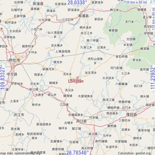
Longtan GPS coordinates[2]
27° 24' 41.004" North, 110° 32' 11.004" East
| Map corner | latitude | longitude |
|---|---|---|
| Upper-left | 28.0338°, | 109.83327° |
| Center: | 27.41139°, | 110.53639° |
| Lower-right: | 26.78546°, | 111.23952° |
| Map W x H: | 138.8×138.8 km | = 86.2×86.2mi |
| max Lat: | 53.31946° ⇑77% North |
| Longtan: | 27.41139° |
| min Lat: | ⇓23% South 18.22056° |
| min Long | Longtan | max Long |
| 75.07348° | 110.53639° | 134.28917° |
| W 31.1%⇐ | ⇒68.9% E |
Elevation
Elevation of Longtan is 490 m = 1608 ft, and this is 5.2 m = 17 ft above average elevation for this country.
| Max E: |
5622 m = 18445 ft | 26.4% |
| Longtan | 490 m 1608 ft | |
| Avg. | 484.8 m = 1591 ft | |
Min E: |
-3 m = -10 ft | 73.6% |
See also: China elevation on elevation.city.
Geographical zone
Longtan is located in North temperate zone (between Tropic of Cancer and the Arctic Circle). Distance of this Northern Tropic circle is 441.9 km =274.6 mi to South.| Distance of | km | miles | from Longtan |
|---|---|---|---|
| North Pole | 6959.2 | 4324.2 | to North |
| Arctic Circle | 4353.3 | 2705 | to North |
| Tropic Cancer | 441.9 | 274.6 | to South |
| Equator | 3047.9 | 1893.9 | to South |


Nearby cities:
15 places around Longtan: (largest is in red/bold)
• Daping
24.3 km =15.1 mi,  251°
251°
• Dashuitian
27.5 km =17.1 mi,  89°
89°
• Huangmaoyuan
6.1 km =3.8 mi,  262°
262°
• Huxingshan
22 km =13.7 mi,  45°
45°
• Jiangkou
27.8 km =17.3 mi,  208°
208°
• Jiuxijiang
28.2 km =17.5 mi,  15°
15°
• Liangyaping
36.6 km =22.7 mi, 21°
• Longtou’an
34.9 km =21.7 mi,  325°
325°
• Matangshan
15.7 km =9.8 mi,  99°
99°
• Shanmen
25.8 km =16 mi,  143°
143°
• Simenqian
35.5 km =22.1 mi,  76°
76°
• Tiepo
16.5 km =10.3 mi,  288°
288°
• Tongwan
31.8 km =19.8 mi,  306°
306°
• Xiaohenglong
21.6 km =13.4 mi,  354°
354°
• Xiaoshajiang
24.2 km =15 mi,  59°
59°
Sources, notices
• [Note1] Compared only with cities in China existing in our database
• [Src1] Map data: © OpenStreetMap contributors (CC-BY-SA)
• [Src2] Other city data from geonames.org with taken over terms of usage.
• [Src3] Geographical zone / Annual Mean Temperature by Robert A. Rohde @ Wikipedia
