Shanmen geodata
Shanmen (Hunan) is a populated place; located in China in Asia/Shanghai (GMT+8) time zone. With population of 3,130 people, there are 939 cities with bigger population in this country. Compared to other cities in China, 77.6% of cities are located further ↑North; 68.3% of cities are located further →East and 66.3% of cities have lower elevation than Shanmen. Note1


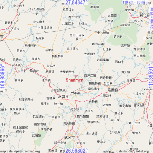
Shanmen GPS coordinates[2]
27° 13' 30" North, 110° 41' 34.008" East
| Map corner | latitude | longitude |
|---|---|---|
| Upper-left | 27.84847°, | 109.98966° |
| Center: | 27.225°, | 110.69278° |
| Lower-right: | 26.59802°, | 111.39591° |
| Map W x H: | 139×139 km | = 86.4×86.4mi |
| max Lat: | 53.31946° ⇑77.6% North |
| Shanmen: | 27.225° |
| min Lat: | ⇓22.4% South 18.22056° |
| min Long | Shanmen | max Long |
| 75.07348° | 110.69278° | 134.28917° |
| W 31.7%⇐ | ⇒68.3% E |
Elevation
Elevation of Shanmen is 348 m = 1142 ft, and this is 136.8 m = 449 ft below average elevation for this country.
| Max E: |
5622 m = 18445 ft | 33.7% |
| Avg. | 484.8 m = 1591 ft | |
| Shanmen | 348 m = 1142 ft | |
Min E: |
-3 m = -10 ft | 66.3% |
See also: China elevation on elevation.city.
Geographical zone
Shanmen is located in North temperate zone (between Tropic of Cancer and the Arctic Circle). Distance of this Northern Tropic circle is 421.2 km =261.7 mi to South.| Distance of | km | miles | from Shanmen |
|---|---|---|---|
| North Pole | 6979.9 | 4337.1 | to North |
| Arctic Circle | 4374 | 2717.9 | to North |
| Tropic Cancer | 421.2 | 261.7 | to South |
| Equator | 3027.1 | 1881 | to South |


Nearby cities:
15 places around Shanmen: (largest is in red/bold)
• Dashuitian
24.2 km =15 mi,  30°
30°
• Dongkou
24.6 km =15.3 mi,  218°
218°
• Hengbanqiao
18.1 km =11.2 mi,  109°
109°
• Hexiangqiao
26.8 km =16.7 mi,  91°
91°
• Huangmaoyuan
29.3 km =18.2 mi,  312°
312°
• Huangqiao
26.9 km =16.7 mi,  147°
147°
• Jiangkou
28.8 km =17.9 mi,  262°
262°
• Liuduzhai
28.6 km =17.8 mi,  56°
56°
• Longtan
25.8 km =16 mi,  323°
323°
• Matangshan
18.1 km =11.2 mi,  0°
0°
• Ma’an
27.7 km =17.2 mi,  174°
174°
• Nanyuemiao
19.1 km =11.9 mi,  124°
124°
• Shijiang
18.8 km =11.7 mi, 147°
• Xiyangjiang
14 km =8.7 mi, 106°
• Zhushi
15.3 km =9.5 mi,  185°
185°
Sources, notices
• [Note1] Compared only with cities in China existing in our database
• [Src1] Map data: © OpenStreetMap contributors (CC-BY-SA)
• [Src2] Other city data from geonames.org with taken over terms of usage.
• [Src3] Geographical zone / Annual Mean Temperature by Robert A. Rohde @ Wikipedia
