Matangshan geodata
Matangshan (Hunan) is a seat of a fourth-order administrative division; located in China in Asia/Shanghai (GMT+8) time zone. In our database, there are 1268 cities with bigger population. Compared to other cities in China, 77.1% of cities are located further ↑North; 68.3% of cities are located further →East and 88.4% of cities have lower elevation than Matangshan. Note1


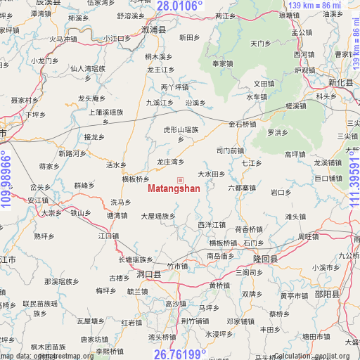
Matangshan GPS coordinates[2]
27° 23' 17.016" North, 110° 41' 34.008" East
| Map corner | latitude | longitude |
|---|---|---|
| Upper-left | 28.0106°, | 109.98966° |
| Center: | 27.38806°, | 110.69278° |
| Lower-right: | 26.76199°, | 111.39591° |
| Map W x H: | 138.8×138.8 km | = 86.2×86.2mi |
| max Lat: | 53.31946° ⇑77.1% North |
| Matangshan: | 27.38806° |
| min Lat: | ⇓22.9% South 18.22056° |
| min Long | Matangshan | max Long |
| 75.07348° | 110.69278° | 134.28917° |
| W 31.7%⇐ | ⇒68.3% E |
Elevation
Elevation of Matangshan is 1217 m = 3993 ft, and this is 732.2 m = 2402 ft above average elevation for this country.
| Max E: |
5622 m = 18445 ft | 11.6% |
| Matangshan | 1217 m 3993 ft | |
| Avg. | 484.8 m = 1591 ft | |
Min E: |
-3 m = -10 ft | 88.4% |
See also: China elevation on elevation.city.
Geographical zone
Matangshan is located in North temperate zone (between Tropic of Cancer and the Arctic Circle). Distance of this Northern Tropic circle is 439.3 km =273 mi to South.| Distance of | km | miles | from Matangshan |
|---|---|---|---|
| North Pole | 6961.8 | 4325.9 | to North |
| Arctic Circle | 4355.9 | 2706.6 | to North |
| Tropic Cancer | 439.3 | 273 | to South |
| Equator | 3045.3 | 1892.3 | to South |


Nearby cities:
15 places around Matangshan: (largest is in red/bold)
• Dashuitian
12.4 km =7.7 mi,  77°
77°
• Hengbanqiao
29.5 km =18.3 mi,  144°
144°
• Hetian
27.9 km =17.3 mi,  99°
99°
• Huangjinjing
29.4 km =18.3 mi,  41°
41°
• Huangmaoyuan
21.6 km =13.4 mi,  274°
274°
• Huxingshan
17.9 km =11.1 mi,  1°
1°
• Liuduzhai
24 km =14.9 mi, 95°
• Longtan
15.7 km =9.8 mi,  279°
279°
• Qijiang
28.5 km =17.7 mi, 76°
• Shanmen
18.1 km =11.2 mi,  180°
180°
• Simenqian
22 km =13.7 mi,  59°
59°
• Xiaohenglong
29.7 km =18.5 mi,  324°
324°
• Xiaoshajiang
15.8 km =9.8 mi,  20°
20°
• Xiyangjiang
25.8 km =16 mi,  148°
148°
• Yanggu’ao
27.1 km =16.8 mi,  66°
66°
Sources, notices
• [Note1] Compared only with cities in China existing in our database
• [Src1] Map data: © OpenStreetMap contributors (CC-BY-SA)
• [Src2] Other city data from geonames.org with taken over terms of usage.
• [Src3] Geographical zone / Annual Mean Temperature by Robert A. Rohde @ Wikipedia
