Huangmaoyuan geodata
Huangmaoyuan (Hunan) is a populated place; located in China in Asia/Shanghai (GMT+8) time zone. With population of 1,910 people, there are 1047 cities with bigger population in this country. Compared to other cities in China, 77% of cities are located further ↑North; 69.2% of cities are located further →East and 76.5% of cities have lower elevation than Huangmaoyuan. Note1


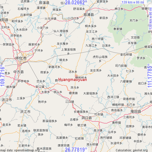
Huangmaoyuan GPS coordinates[2]
27° 24' 15.012" North, 110° 28' 28.992" East
| Map corner | latitude | longitude |
|---|---|---|
| Upper-left | 28.02662°, | 109.7716° |
| Center: | 27.40417°, | 110.47472° |
| Lower-right: | 26.77819°, | 111.17785° |
| Map W x H: | 138.8×138.8 km | = 86.2×86.2mi |
| max Lat: | 53.31946° ⇑77% North |
| Huangmaoyuan: | 27.40417° |
| min Lat: | ⇓23% South 18.22056° |
| min Long | Huangmaoyuan | max Long |
| 75.07348° | 110.47472° | 134.28917° |
| W 30.8%⇐ | ⇒69.2% E |
Elevation
Elevation of Huangmaoyuan is 561 m = 1841 ft, and this is 76.2 m = 250 ft above average elevation for this country.
| Max E: |
5622 m = 18445 ft | 23.5% |
| Huangmaoyuan | 561 m 1841 ft | |
| Avg. | 484.8 m = 1591 ft | |
Min E: |
-3 m = -10 ft | 76.5% |
See also: China elevation on elevation.city.
Geographical zone
Huangmaoyuan is located in North temperate zone (between Tropic of Cancer and the Arctic Circle). Distance of this Northern Tropic circle is 441.1 km =274.1 mi to South.| Distance of | km | miles | from Huangmaoyuan |
|---|---|---|---|
| North Pole | 6960 | 4324.7 | to North |
| Arctic Circle | 4354.1 | 2705.5 | to North |
| Tropic Cancer | 441.1 | 274.1 | to South |
| Equator | 3047.1 | 1893.4 | to South |


Nearby cities:
15 places around Huangmaoyuan: (largest is in red/bold)
• Anjiang
37.9 km =23.5 mi,  255°
255°
• Daping
18.3 km =11.4 mi,  247°
247°
• Dashuitian
33.6 km =20.9 mi,  88°
88°
• Huangxikou
36.1 km =22.4 mi,  345°
345°
• Huxingshan
27.2 km =16.9 mi,  53°
53°
• Jiangkou
24.7 km =15.3 mi,  196°
196°
• Jiuxijiang
31.1 km =19.3 mi,  26°
26°
• Longtan
6.1 km =3.8 mi,  82°
82°
• Longtou’an
32.6 km =20.3 mi,  335°
335°
• Matangshan
21.6 km =13.4 mi, 94°
• Shanmen
29.3 km =18.2 mi,  132°
132°
• Tiepo
11.3 km =7 mi,  302°
302°
• Tongwan
27.7 km =17.2 mi,  315°
315°
• Xiaohenglong
22.7 km =14.1 mi,  10°
10°
• Xiaoshajiang
30 km =18.6 mi,  64°
64°
Sources, notices
• [Note1] Compared only with cities in China existing in our database
• [Src1] Map data: © OpenStreetMap contributors (CC-BY-SA)
• [Src2] Other city data from geonames.org with taken over terms of usage.
• [Src3] Geographical zone / Annual Mean Temperature by Robert A. Rohde @ Wikipedia
