Longsheng geodata
Longsheng (Guangxi) is a seat of a third-order administrative division; located in China in Asia/Shanghai (GMT+8) time zone. In our database, there are 1268 cities with bigger population. Compared to other cities in China, 83.2% of cities are located further ↑North; 71.2% of cities are located further →East and 66.9% of cities have lower elevation than Longsheng. Note1


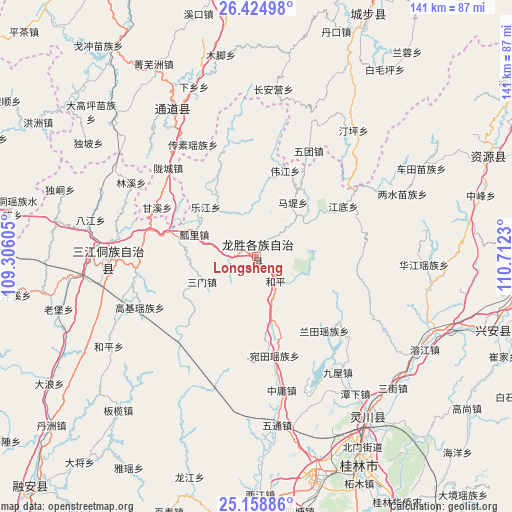
Longsheng GPS coordinates[2]
25° 47' 36.996" North, 110° 0' 33.012" East
| Map corner | latitude | longitude |
|---|---|---|
| Upper-left | 26.42498°, | 109.30605° |
| Center: | 25.79361°, | 110.00917° |
| Lower-right: | 25.15886°, | 110.7123° |
| Map W x H: | 140.8×140.8 km | = 87.5×87.5mi |
| max Lat: | 53.31946° ⇑83.2% North |
| Longsheng: | 25.79361° |
| min Lat: | ⇓16.8% South 18.22056° |
| min Long | Longsheng | max Long |
| 75.07348° | 110.00917° | 134.28917° |
| W 28.8%⇐ | ⇒71.2% E |
Elevation
Elevation of Longsheng is 357 m = 1171 ft, and this is 127.8 m = 419 ft below average elevation for this country.
| Max E: |
5622 m = 18445 ft | 33.1% |
| Avg. | 484.8 m = 1591 ft | |
| Longsheng | 357 m = 1171 ft | |
Min E: |
-3 m = -10 ft | 66.9% |
See also: China elevation on elevation.city.
Geographical zone
Longsheng is located in North temperate zone (between Tropic of Cancer and the Arctic Circle). Distance of this Northern Tropic circle is 262.1 km =162.9 mi to South.| Distance of | km | miles | from Longsheng |
|---|---|---|---|
| North Pole | 7139.1 | 4436 | to North |
| Arctic Circle | 4533.2 | 2816.8 | to North |
| Tropic Cancer | 262.1 | 162.9 | to South |
| Equator | 2868 | 1782.1 | to South |


Nearby cities:
15 places around Longsheng: (largest is in red/bold)
• Baimaoping
63 km =39.1 mi,  34°
34°
• Chang’anying
52.9 km =32.9 mi,  8°
8°
• Dankou
67.1 km =41.7 mi,  20°
20°
• Dazhai
14.2 km =8.8 mi,  82°
82°
• Diyangping
66.9 km =41.6 mi,  322°
322°
• Guilin
63.3 km =39.3 mi,  153°
153°
• Guyi
41 km =25.5 mi,  267°
267°
• Jiangtousi
40.9 km =25.4 mi, 23°
• Lingchuan
53 km =32.9 mi,  143°
143°
• Linkou
52.6 km =32.7 mi,  343°
343°
• Longcheng
35.4 km =22 mi, 319°
• Rulin
66.7 km =41.4 mi, 22°
• Shuangjiang
49.8 km =30.9 mi, 323°
• Xing’an
66.3 km =41.2 mi,  106°
106°
• Yatunpu
55.5 km =34.5 mi, 316°
Sources, notices
• [Note1] Compared only with cities in China existing in our database
• [Src1] Map data: © OpenStreetMap contributors (CC-BY-SA)
• [Src2] Other city data from geonames.org with taken over terms of usage.
• [Src3] Geographical zone / Annual Mean Temperature by Robert A. Rohde @ Wikipedia
