Guyi geodata
Guyi (Guangxi) is a seat of a third-order administrative division; located in China in Asia/Shanghai (GMT+8) time zone. In our database, there are 1268 cities with bigger population. Compared to other cities in China, 83.3% of cities are located further ↑North; 73.3% of cities are located further →East and 50.5% of cities have higher elevation than Guyi. Note1


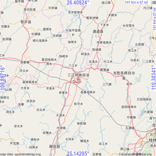
Guyi GPS coordinates[2]
25° 46' 40.008" North, 109° 36' 1.008" East
| Map corner | latitude | longitude |
|---|---|---|
| Upper-left | 26.40924°, | 108.89716° |
| Center: | 25.77778°, | 109.60028° |
| Lower-right: | 25.14295°, | 110.30341° |
| Map W x H: | 140.8×140.8 km | = 87.5×87.5mi |
| max Lat: | 53.31946° ⇑83.3% North |
| Guyi: | 25.77778° |
| min Lat: | ⇓16.7% South 18.22056° |
| min Long | Guyi | max Long |
| 75.07348° | 109.60028° | 134.28917° |
| W 26.7%⇐ | ⇒73.3% E |
Elevation
Elevation of Guyi is 160 m = 525 ft, and this is 324.8 m = 1066 ft below average elevation for this country.
| Max E: |
5622 m = 18445 ft | 50.5% |
| Avg. | 484.8 m = 1591 ft | |
| Guyi | 160 m = 525 ft | |
Min E: |
-3 m = -10 ft | 49.5% |
See also: China elevation on elevation.city.
Geographical zone
Guyi is located in North temperate zone (between Tropic of Cancer and the Arctic Circle). Distance of this Northern Tropic circle is 260.3 km =161.7 mi to South.| Distance of | km | miles | from Guyi |
|---|---|---|---|
| North Pole | 7140.8 | 4437.1 | to North |
| Arctic Circle | 4535 | 2817.9 | to North |
| Tropic Cancer | 260.3 | 161.7 | to South |
| Equator | 2866.2 | 1781 | to South |


Nearby cities:
15 places around Guyi: (largest is in red/bold)
• Boyang
48.9 km =30.4 mi,  350°
350°
• Dazhai
55.1 km =34.2 mi,  86°
86°
• Diyangping
55 km =34.2 mi,  0°
0°
• Dundong
52.8 km =32.8 mi,  299°
299°
• Hongzhou
43.2 km =26.8 mi,  333°
333°
• Linkou
58.5 km =36.4 mi,  26°
26°
• Longcheng
33.5 km =20.8 mi, 31°
• Longsheng
41 km =25.5 mi, 87°
• Rong’an
64.3 km =40 mi,  199°
199°
• Shuangjiang
43.4 km =27 mi,  15°
15°
• Xianxi
62.1 km =38.6 mi, 3°
• Xishan
64.6 km =40.1 mi,  260°
260°
• Yatunpu
42 km =26.1 mi, 3°
• Yongcong
55.4 km =34.4 mi, 302°
• Zhongchao
55.2 km =34.3 mi,  316°
316°
Sources, notices
• [Note1] Compared only with cities in China existing in our database
• [Src1] Map data: © OpenStreetMap contributors (CC-BY-SA)
• [Src2] Other city data from geonames.org with taken over terms of usage.
• [Src3] Geographical zone / Annual Mean Temperature by Robert A. Rohde @ Wikipedia
