Dazhai geodata
Dazhai (Guangxi) is a populated place; located in China in Asia/Shanghai (GMT+8) time zone. With population of 2,000 people, there are 1030 cities with bigger population in this country. Compared to other cities in China, 83.1% of cities are located further ↑North; 70.6% of cities are located further →East and 83.2% of cities have lower elevation than Dazhai. Note1


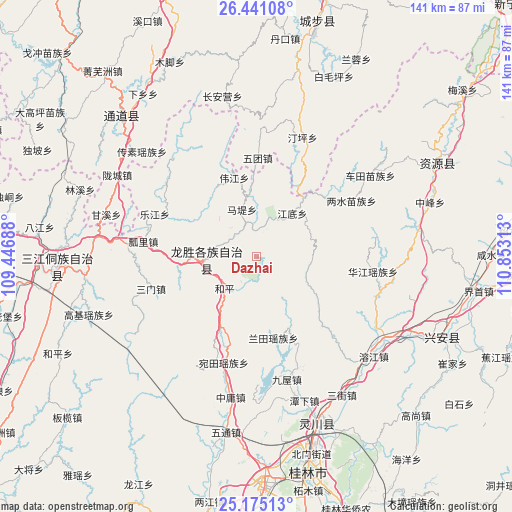
Dazhai GPS coordinates[2]
25° 48' 35.28" North, 110° 9' 0" East
| Map corner | latitude | longitude |
|---|---|---|
| Upper-left | 26.44108°, | 109.44688° |
| Center: | 25.8098°, | 110.15° |
| Lower-right: | 25.17513°, | 110.85313° |
| Map W x H: | 140.8×140.8 km | = 87.5×87.5mi |
| max Lat: | 53.31946° ⇑83.1% North |
| Dazhai: | 25.8098° |
| min Lat: | ⇓16.9% South 18.22056° |
| min Long | Dazhai | max Long |
| 75.07348° | 110.15° | 134.28917° |
| W 29.4%⇐ | ⇒70.6% E |
Elevation
Elevation of Dazhai is 862 m = 2828 ft, and this is 377.2 m = 1238 ft above average elevation for this country.
| Max E: |
5622 m = 18445 ft | 16.8% |
| Dazhai | 862 m 2828 ft | |
| Avg. | 484.8 m = 1591 ft | |
Min E: |
-3 m = -10 ft | 83.2% |
See also: China elevation on elevation.city.
Geographical zone
Dazhai is located in North temperate zone (between Tropic of Cancer and the Arctic Circle). Distance of this Northern Tropic circle is 263.9 km =164 mi to South.| Distance of | km | miles | from Dazhai |
|---|---|---|---|
| North Pole | 7137.3 | 4434.9 | to North |
| Arctic Circle | 4531.4 | 2815.7 | to North |
| Tropic Cancer | 263.9 | 164 | to South |
| Equator | 2869.8 | 1783.2 | to South |


Nearby cities:
15 places around Dazhai: (largest is in red/bold)
• Baimaoping
54.6 km =33.9 mi,  23°
23°
• Chang’anying
50.9 km =31.6 mi,  353°
353°
• Dankou
61.8 km =38.4 mi,  8°
8°
• Guilin
60.3 km =37.5 mi,  166°
166°
• Guyi
55.1 km =34.2 mi,  266°
266°
• Jiangtousi
35.8 km =22.2 mi,  3°
3°
• Lingchuan
47.8 km =29.7 mi,  158°
158°
• Linkou
56.5 km =35.1 mi,  329°
329°
• Longcheng
44.8 km =27.8 mi,  303°
303°
• Longsheng
14.2 km =8.8 mi,  262°
262°
• Rulin
60.9 km =37.8 mi, 11°
• Shuangjiang
58.1 km =36.1 mi,  311°
311°
• Xing’an
53.7 km =33.4 mi,  113°
113°
• Yatunpu
64.9 km =40.3 mi, 306°
• Ziyuan
55.2 km =34.3 mi,  62°
62°
Sources, notices
• [Note1] Compared only with cities in China existing in our database
• [Src1] Map data: © OpenStreetMap contributors (CC-BY-SA)
• [Src2] Other city data from geonames.org with taken over terms of usage.
• [Src3] Geographical zone / Annual Mean Temperature by Robert A. Rohde @ Wikipedia
