Le’an geodata
Le’an (Hunan) is a seat of a fourth-order administrative division; located in China in Asia/Shanghai (GMT+8) time zone. In our database, there are 1268 cities with bigger population. Compared to other cities in China, 73.4% of cities are located further ↑North; 64.6% of cities are located further →East and 68.1% of cities have lower elevation than Le’an. Note1


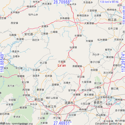
Le’an GPS coordinates[2]
28° 5' 29.004" North, 111° 35' 18.996" East
| Map corner | latitude | longitude |
|---|---|---|
| Upper-left | 28.70988°, | 110.88549° |
| Center: | 28.09139°, | 111.58861° |
| Lower-right: | 27.46931°, | 112.29174° |
| Map W x H: | 137.9×137.9 km | = 85.7×85.7mi |
| max Lat: | 53.31946° ⇑73.4% North |
| Le’an: | 28.09139° |
| min Lat: | ⇓26.6% South 18.22056° |
| min Long | Le’an | max Long |
| 75.07348° | 111.58861° | 134.28917° |
| W 35.4%⇐ | ⇒64.6% E |
Elevation
Elevation of Le’an is 378 m = 1240 ft, and this is 106.8 m = 350 ft below average elevation for this country.
| Max E: |
5622 m = 18445 ft | 31.9% |
| Avg. | 484.8 m = 1591 ft | |
| Le’an | 378 m = 1240 ft | |
Min E: |
-3 m = -10 ft | 68.1% |
See also: China elevation on elevation.city.
Geographical zone
Le’an is located in North temperate zone (between Tropic of Cancer and the Arctic Circle). Distance of this Northern Tropic circle is 517.6 km =321.6 mi to South.| Distance of | km | miles | from Le’an |
|---|---|---|---|
| North Pole | 6883.6 | 4277.3 | to North |
| Arctic Circle | 4277.7 | 2658 | to North |
| Tropic Cancer | 517.6 | 321.6 | to South |
| Equator | 3123.5 | 1940.9 | to South |


Nearby cities:
15 places around Le’an: (largest is in red/bold)
• Baixi
28.8 km =17.9 mi,  252°
252°
• Changtang
34.6 km =21.5 mi,  31°
31°
• Gulou
48.6 km =30.2 mi,  279°
279°
• Langtang
44.2 km =27.5 mi,  257°
257°
• Lengshuijiang
47.5 km =29.5 mi,  199°
199°
• Lianyuan
45.4 km =28.2 mi,  170°
170°
• Longtang
43.1 km =26.8 mi,  334°
334°
• Longtian
34.8 km =21.6 mi,  103°
103°
• Qingtangpu
17.7 km =11 mi, 104°
• Shangmei
48.3 km =30 mi,  216°
216°
• Silihe
42.4 km =26.3 mi, 32°
• Xiangzikou
35.9 km =22.3 mi,  87°
87°
• Xianxi
20.5 km =12.7 mi, 33°
• Yangjiaotang
49.4 km =30.7 mi,  3°
3°
• Zhenshang
20.2 km =12.6 mi,  272°
272°
Sources, notices
• [Note1] Compared only with cities in China existing in our database
• [Src1] Map data: © OpenStreetMap contributors (CC-BY-SA)
• [Src2] Other city data from geonames.org with taken over terms of usage.
• [Src3] Geographical zone / Annual Mean Temperature by Robert A. Rohde @ Wikipedia
