Lianyuan geodata
Lianyuan (Hunan) is a seat of a third-order administrative division; located in China in Asia/Shanghai (GMT+8) time zone. With population of 66,501 people, there are 646 cities with bigger population in this country. Compared to other cities in China, 75.8% of cities are located further ↑North; 64.2% of cities are located further →East and 51.8% of cities have higher elevation than Lianyuan. Note1


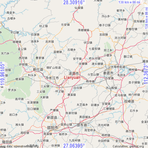
Lianyuan GPS coordinates[2]
27° 41' 17.988" North, 111° 39' 51.012" East
| Map corner | latitude | longitude |
|---|---|---|
| Upper-left | 28.30916°, | 110.96105° |
| Center: | 27.68833°, | 111.66417° |
| Lower-right: | 27.06395°, | 112.3673° |
| Map W x H: | 138.5×138.5 km | = 86.1×86.1mi |
| max Lat: | 53.31946° ⇑75.8% North |
| Lianyuan: | 27.68833° |
| min Lat: | ⇓24.2% South 18.22056° |
| min Long | Lianyuan | max Long |
| 75.07348° | 111.66417° | 134.28917° |
| W 35.8%⇐ | ⇒64.2% E |
Elevation
Elevation of Lianyuan is 151 m = 495 ft, and this is 333.8 m = 1095 ft below average elevation for this country.
| Max E: |
5622 m = 18445 ft | 51.8% |
| Avg. | 484.8 m = 1591 ft | |
| Lianyuan | 151 m = 495 ft | |
Min E: |
-3 m = -10 ft | 48.2% |
See also: Lianyuan elevation on elevation.city.
Geographical zone
Lianyuan is located in North temperate zone (between Tropic of Cancer and the Arctic Circle). Distance of this Northern Tropic circle is 472.7 km =293.7 mi to South.| Distance of | km | miles | from Lianyuan |
|---|---|---|---|
| North Pole | 6928.4 | 4305.1 | to North |
| Arctic Circle | 4322.5 | 2685.9 | to North |
| Tropic Cancer | 472.7 | 293.7 | to South |
| Equator | 3078.7 | 1913 | to South |


Nearby cities:
15 places around Lianyuan: (largest is in red/bold)
• Baixi
50.2 km =31.2 mi,  315°
315°
• Gaoping
56.4 km =35 mi,  245°
245°
• Langtang
61.7 km =38.3 mi,  304°
304°
• Lengshuijiang
23.1 km =14.4 mi,  269°
269°
• Le’an
45.4 km =28.2 mi,  350°
350°
• Liangshi
54.1 km =33.6 mi,  172°
172°
• Longtian
45.1 km =28 mi,  35°
35°
• Loudi
32.9 km =20.4 mi,  81°
81°
• Luohong
59.9 km =37.2 mi,  255°
255°
• Niangxi
48 km =29.8 mi,  208°
208°
• Qingtangpu
41.6 km =25.8 mi,  13°
13°
• Shangmei
36.8 km =22.9 mi,  279°
279°
• Xiangzikou
54.2 km =33.7 mi,  31°
31°
• Yongfeng
58.8 km =36.5 mi,  119°
119°
• Zhenshang
53.4 km =33.2 mi,  328°
328°
Sources, notices
• [Note1] Compared only with cities in China existing in our database
• [Src1] Map data: © OpenStreetMap contributors (CC-BY-SA)
• [Src2] Other city data from geonames.org with taken over terms of usage.
• [Src3] Geographical zone / Annual Mean Temperature by Robert A. Rohde @ Wikipedia
