Lengshuijiang geodata
Lengshuijiang (Hunan) is a populated place; located in China in Asia/Shanghai (GMT+8) time zone. With population of 115,399 people, there are 376 cities with bigger population in this country. Compared to other cities in China, 75.8% of cities are located further ↑North; 65.4% of cities are located further →East and 53.6% of cities have lower elevation than Lengshuijiang. Note1


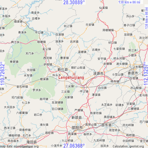
Lengshuijiang GPS coordinates[2]
27° 41' 17.016" North, 111° 25' 45.984" East
| Map corner | latitude | longitude |
|---|---|---|
| Upper-left | 28.30889°, | 110.72632° |
| Center: | 27.68806°, | 111.42944° |
| Lower-right: | 27.06368°, | 112.13257° |
| Map W x H: | 138.5×138.5 km | = 86.1×86.1mi |
| max Lat: | 53.31946° ⇑75.8% North |
| Lengshuijiang: | 27.68806° |
| min Lat: | ⇓24.2% South 18.22056° |
| min Long | Lengshuijiang | max Long |
| 75.07348° | 111.42944° | 134.28917° |
| W 34.6%⇐ | ⇒65.4% E |
Elevation
Elevation of Lengshuijiang is 194 m = 636 ft, and this is 290.8 m = 954 ft below average elevation for this country.
| Max E: |
5622 m = 18445 ft | 46.4% |
| Avg. | 484.8 m = 1591 ft | |
| Lengshuijiang | 194 m = 636 ft | |
Min E: |
-3 m = -10 ft | 53.6% |
See also: Lengshuijiang elevation on elevation.city.
Geographical zone
Lengshuijiang is located in North temperate zone (between Tropic of Cancer and the Arctic Circle). Distance of this Northern Tropic circle is 472.7 km =293.7 mi to South.| Distance of | km | miles | from Lengshuijiang |
|---|---|---|---|
| North Pole | 6928.4 | 4305.1 | to North |
| Arctic Circle | 4322.6 | 2685.9 | to North |
| Tropic Cancer | 472.7 | 293.7 | to South |
| Equator | 3078.6 | 1913 | to South |


Nearby cities:
15 places around Lengshuijiang: (largest is in red/bold)
• Baixi
38 km =23.6 mi,  341°
341°
• Gaoping
36.5 km =22.7 mi,  230°
230°
• Jinshiqiao
49.9 km =31 mi,  256°
256°
• Langtang
44.8 km =27.8 mi,  321°
321°
• Le’an
47.5 km =29.5 mi,  19°
19°
• Lianyuan
23.1 km =14.4 mi,  89°
89°
• Luohong
37.9 km =23.5 mi,  247°
247°
• Niangxi
42.2 km =26.2 mi,  179°
179°
• Qingtangpu
52.1 km =32.4 mi,  39°
39°
• Shangmei
14.5 km =9 mi,  294°
294°
• Shuiche
42.3 km =26.3 mi,  269°
269°
• Xixi
46.9 km =29.1 mi, 270°
• Yankou
50.6 km =31.4 mi,  221°
221°
• Yatian
42.3 km =26.3 mi, 255°
• Zhenshang
46 km =28.6 mi,  354°
354°
Sources, notices
• [Note1] Compared only with cities in China existing in our database
• [Src1] Map data: © OpenStreetMap contributors (CC-BY-SA)
• [Src2] Other city data from geonames.org with taken over terms of usage.
• [Src3] Geographical zone / Annual Mean Temperature by Robert A. Rohde @ Wikipedia
