Huazangsi geodata
Huazangsi (Gansu) is a seat of a third-order administrative division; located in China in Asia/Shanghai (GMT+8) time zone. In our database, there are 1268 cities with bigger population. Compared to other cities in China, 79.1% of cities are located further ↓South; 91.3% of cities are located further →East and 95.7% of cities have lower elevation than Huazangsi. Note1


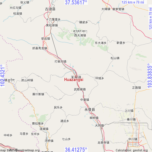
Huazangsi GPS coordinates[2]
36° 58' 35.508" North, 103° 8' 6.792" East
| Map corner | latitude | longitude |
|---|---|---|
| Upper-left | 37.53617°, | 102.4321° |
| Center: | 36.97653°, | 103.13522° |
| Lower-right: | 36.41275°, | 103.83835° |
| Map W x H: | 124.9×124.9 km | = 77.6×77.6mi |
| max Lat: | 53.31946° ⇑20.9% North |
| Huazangsi: | 36.97653° |
| min Lat: | ⇓79.1% South 18.22056° |
| min Long | Huazangsi | max Long |
| 75.07348° | 103.13522° | 134.28917° |
| W 8.7%⇐ | ⇒91.3% E |
Elevation
Elevation of Huazangsi is 2407 m = 7897 ft, and this is 1922.2 m = 6306 ft above average elevation for this country.
| Max E: |
5622 m = 18445 ft | 4.3% |
| Huazangsi | 2407 m 7897 ft | |
| Avg. | 484.8 m = 1591 ft | |
Min E: |
-3 m = -10 ft | 95.7% |
See also: China elevation on elevation.city.
Geographical zone
Huazangsi is located in North temperate zone (between Tropic of Cancer and the Arctic Circle). Distance of this Northern Tropic circle is 1505.5 km =935.5 mi to South.| Distance of | km | miles | from Huazangsi |
|---|---|---|---|
| North Pole | 5895.7 | 3663.4 | to North |
| Arctic Circle | 3289.8 | 2044.2 | to North |
| Tropic Cancer | 1505.5 | 935.5 | to South |
| Equator | 4111.4 | 2554.7 | to South |


Nearby cities:
15 places around Huazangsi: (largest is in red/bold)
• Anning Xilu
110.2 km =68.5 mi,  151°
151°
• Baiyin
103.8 km =64.5 mi,  117°
117°
• Dongdajie
114.5 km =71.1 mi,  337°
337°
• Fulilu
106.3 km =66.1 mi,  156°
156°
• Gaolan Chengguanzhen
101.6 km =63.1 mi,  134°
134°
• Gaozhai
113.1 km =70.3 mi,  244°
244°
• Gulang
58.5 km =36.4 mi, 338°
• Haishiwan
74.3 km =46.2 mi,  199°
199°
• Nanmenxia
109.1 km =67.8 mi,  270°
270°
• Renminlu
103.6 km =64.4 mi, 117°
• Wangjia
111.5 km =69.3 mi, 195°
• Weiyuan
102.6 km =63.8 mi,  262°
262°
• Wuwei
114.6 km =71.2 mi, 337°
• Yitiaoshan
84.5 km =52.5 mi,  76°
76°
• Yongdeng Chengguanzhen
29.2 km =18.1 mi, 157°
Sources, notices
• [Note1] Compared only with cities in China existing in our database
• [Src1] Map data: © OpenStreetMap contributors (CC-BY-SA)
• [Src2] Other city data from geonames.org with taken over terms of usage.
• [Src3] Geographical zone / Annual Mean Temperature by Robert A. Rohde @ Wikipedia
