Baiyin geodata
Baiyin (Gansu) is a seat of a second-order administrative division; located in China in Asia/Shanghai (GMT+8) time zone. With population of 188,533 people, there are 241 cities with bigger population in this country. Compared to other cities in China, 78.3% of cities are located further ↓South; 90.1% of cities are located further →East and 93.1% of cities have lower elevation than Baiyin. Note1


Baiyin GPS coordinates[2]
36° 32' 49.056" North, 104° 10' 12.828" East
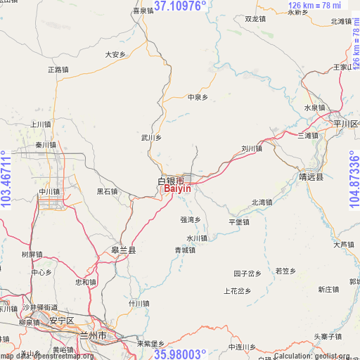
| Map corner | latitude | longitude |
|---|---|---|
| Upper-left | 37.10976°, | 103.46711° |
| Center: | 36.54696°, | 104.17023° |
| Lower-right: | 35.98003°, | 104.87336° |
| Map W x H: | 125.6×125.6 km | = 78×78mi |
| max Lat: | 53.31946° ⇑21.7% North |
| Baiyin: | 36.54696° |
| min Lat: | ⇓78.3% South 18.22056° |
| min Long | Baiyin | max Long |
| 75.07348° | 104.17023° | 134.28917° |
| W 9.9%⇐ | ⇒90.1% E |
Elevation
Elevation of Baiyin is 1723 m = 5653 ft, and this is 1238.2 m = 4062 ft above average elevation for this country.
| Max E: |
5622 m = 18445 ft | 6.9% |
| Baiyin | 1723 m 5653 ft | |
| Avg. | 484.8 m = 1591 ft | |
Min E: |
-3 m = -10 ft | 93.1% |
See also: Baiyin elevation on elevation.city.
Geographical zone
Baiyin is located in North temperate zone (between Tropic of Cancer and the Arctic Circle). Distance of this Northern Tropic circle is 1457.7 km =905.8 mi to South.| Distance of | km | miles | from Baiyin |
|---|---|---|---|
| North Pole | 5943.4 | 3693.1 | to North |
| Arctic Circle | 3337.5 | 2073.8 | to North |
| Tropic Cancer | 1457.7 | 905.8 | to South |
| Equator | 4063.6 | 2525 | to South |


Nearby cities:
15 places around Baiyin: (largest is in red/bold)
• Anning Xilu
63.7 km =39.6 mi,  219°
219°
• Fulilu
70.1 km =43.6 mi,  225°
225°
• Gangouyi
100.5 km =62.4 mi,  130°
130°
• Gaolan Chengguanzhen
31 km =19.3 mi, 220°
• Huazangsi
103.8 km =64.5 mi,  297°
297°
• Lanzhou
62 km =38.5 mi,  208°
208°
• Liujiaxia
102.4 km =63.6 mi, 228°
• Renminlu
0.5 km =0.3 mi,  352°
352°
• Wulan
45.9 km =28.5 mi,  87°
87°
• Xihu
63.9 km =39.7 mi, 213°
• Xingpinglu
60.8 km =37.8 mi,  70°
70°
• Yitiaoshan
68.1 km =42.3 mi, 351°
• Yongdeng Chengguanzhen
83.9 km =52.1 mi,  284°
284°
• Yuzhong Chengguanzhen
78.5 km =48.8 mi,  183°
183°
• Zhangyelu
62.7 km =39 mi, 209°
Sources, notices
• [Note1] Compared only with cities in China existing in our database
• [Src1] Map data: © OpenStreetMap contributors (CC-BY-SA)
• [Src2] Other city data from geonames.org with taken over terms of usage.
• [Src3] Geographical zone / Annual Mean Temperature by Robert A. Rohde @ Wikipedia
