Shengli geodata
Shengli (Shandong) is a seat of a third-order administrative division; located in China in Asia/Shanghai (GMT+8) time zone. With population of 306,450 people, there are 178 cities with bigger population in this country. Compared to other cities in China, 80.2% of cities are located further ↓South; 73.2% of cities are located further ←West and 95.9% of cities have higher elevation than Shengli. Note1


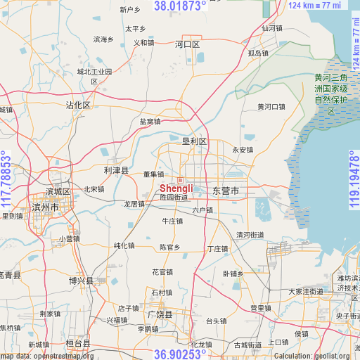
Shengli GPS coordinates[2]
37° 27' 45.756" North, 118° 29' 29.94" East
| Map corner | latitude | longitude |
|---|---|---|
| Upper-left | 38.01873°, | 117.78853° |
| Center: | 37.46271°, | 118.49165° |
| Lower-right: | 36.90253°, | 119.19478° |
| Map W x H: | 124.1×124.1 km | = 77.1×77.1mi |
| max Lat: | 53.31946° ⇑19.8% North |
| Shengli: | 37.46271° |
| min Lat: | ⇓80.2% South 18.22056° |
| min Long | Shengli | max Long |
| 75.07348° | 118.49165° | 134.28917° |
| W 73.2%⇐ | ⇒26.8% E |
Elevation
Elevation of Shengli is 6 m = 20 ft, and this is 478.8 m = 1571 ft below average elevation for this country.
| Max E: |
5622 m = 18445 ft | 95.9% |
| Avg. | 484.8 m = 1591 ft | |
| Shengli | 6 m = 20 ft | |
Min E: |
-3 m = -10 ft | 4.1% |
See also: Shengli elevation on elevation.city.
Geographical zone
Shengli is located in North temperate zone (between Tropic of Cancer and the Arctic Circle). Distance of this Northern Tropic circle is 1559.5 km =969 mi to South.| Distance of | km | miles | from Shengli |
|---|---|---|---|
| North Pole | 5841.6 | 3629.8 | to North |
| Arctic Circle | 3235.7 | 2010.6 | to North |
| Tropic Cancer | 1559.5 | 969 | to South |
| Equator | 4165.5 | 2588.3 | to South |


Nearby cities:
15 places around Shengli: (largest is in red/bold)
• Binzhou
43.3 km =26.9 mi,  255°
255°
• Guangrao
22.7 km =14.1 mi,  186°
186°
• Guangrao
46.3 km =28.8 mi, 190°
• Hanting
99.9 km =62.1 mi,  140°
140°
• Hekou
47 km =29.2 mi,  3°
3°
• Nanding
88.3 km =54.9 mi,  205°
205°
• Qingzhou
85.2 km =52.9 mi,  180°
180°
• Shouguang
68.4 km =42.5 mi,  161°
161°
• Suozhen
66.1 km =41.1 mi, 211°
• Weifang
99.7 km =62 mi,  147°
147°
• Xindian
76 km =47.2 mi, 193°
• Yangxin
83.2 km =51.7 mi,  284°
284°
• Yangzi
74.8 km =46.5 mi,  128°
128°
• Zhoucun
93.5 km =58.1 mi,  219°
219°
• Zibo
83.8 km =52.1 mi, 206°
Sources, notices
• [Note1] Compared only with cities in China existing in our database
• [Src1] Map data: © OpenStreetMap contributors (CC-BY-SA)
• [Src2] Other city data from geonames.org with taken over terms of usage.
• [Src3] Geographical zone / Annual Mean Temperature by Robert A. Rohde @ Wikipedia
