Dongtang geodata
Dongtang (Guangdong) is a seat of a fourth-order administrative division; located in China in Asia/Shanghai (GMT+8) time zone. In our database, there are 1268 cities with bigger population. Compared to other cities in China, 86% of cities are located further ↑North; 53.5% of cities are located further →East and 59.5% of cities have higher elevation than Dongtang. Note1


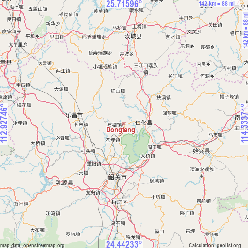
Dongtang GPS coordinates[2]
25° 4' 50.88" North, 113° 37' 50.088" East
| Map corner | latitude | longitude |
|---|---|---|
| Upper-left | 25.71596°, | 112.92746° |
| Center: | 25.0808°, | 113.63058° |
| Lower-right: | 24.44233°, | 114.33371° |
| Map W x H: | 141.6×141.6 km | = 88×88mi |
| max Lat: | 53.31946° ⇑86% North |
| Dongtang: | 25.0808° |
| min Lat: | ⇓14% South 18.22056° |
| min Long | Dongtang | max Long |
| 75.07348° | 113.63058° | 134.28917° |
| W 46.5%⇐ | ⇒53.5% E |
Elevation
Elevation of Dongtang is 101 m = 331 ft, and this is 383.8 m = 1259 ft below average elevation for this country.
| Max E: |
5622 m = 18445 ft | 59.5% |
| Avg. | 484.8 m = 1591 ft | |
| Dongtang | 101 m = 331 ft | |
Min E: |
-3 m = -10 ft | 40.5% |
See also: China elevation on elevation.city.
Geographical zone
Dongtang is located in North temperate zone (between Tropic of Cancer and the Arctic Circle). Distance of this Northern Tropic circle is 182.8 km =113.6 mi to South.| Distance of | km | miles | from Dongtang |
|---|---|---|---|
| North Pole | 7218.3 | 4485.2 | to North |
| Arctic Circle | 4612.5 | 2866.1 | to North |
| Tropic Cancer | 182.8 | 113.6 | to South |
| Equator | 2788.7 | 1732.8 | to South |


Nearby cities:
15 places around Dongtang: (largest is in red/bold)
• Changlai
23.8 km =14.8 mi,  271°
271°
• Danxia
12.5 km =7.8 mi,  107°
107°
• Daqiao
22.7 km =14.1 mi,  146°
146°
• Guitou
27.1 km =16.8 mi,  232°
232°
• Hongshan
19.8 km =12.3 mi,  348°
348°
• Huangkeng
19.1 km =11.9 mi,  97°
97°
• Huaping
9.5 km =5.9 mi,  217°
217°
• Langtian
19.7 km =12.2 mi,  294°
294°
• Lishi
22.6 km =14 mi,  208°
208°
• Renhua
11.5 km =7.1 mi,  84°
84°
• Shiliting
26.7 km =16.6 mi,  194°
194°
• Shitang
6.4 km =4 mi,  264°
264°
• Wenshao
26.4 km =16.4 mi, 75°
• Wushan
24.2 km =15 mi,  321°
321°
• Zhoutian
22.1 km =13.7 mi,  125°
125°
Sources, notices
• [Note1] Compared only with cities in China existing in our database
• [Src1] Map data: © OpenStreetMap contributors (CC-BY-SA)
• [Src2] Other city data from geonames.org with taken over terms of usage.
• [Src3] Geographical zone / Annual Mean Temperature by Robert A. Rohde @ Wikipedia
