Huangkeng geodata
Huangkeng (Guangdong) is a seat of a fourth-order administrative division; located in China in Asia/Shanghai (GMT+8) time zone. In our database, there are 1268 cities with bigger population. Compared to other cities in China, 86.1% of cities are located further ↑North; 52.4% of cities are located further →East and 59% of cities have higher elevation than Huangkeng. Note1


Huangkeng GPS coordinates[2]
25° 3' 30.456" North, 113° 49' 8.292" East
| Map corner | latitude | longitude |
|---|---|---|
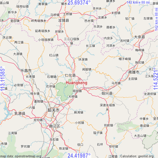
| Upper-left | 25.69374°, | 113.11585° |
| Center: | 25.05846°, | 113.81897° |
| Lower-right: | 24.41987°, | 114.5221° |
| Map W x H: | 141.6×141.6 km | = 88×88mi |
| max Lat: | 53.31946° ⇑86.1% North |
| Huangkeng: | 25.05846° |
| min Lat: | ⇓13.9% South 18.22056° |
| min Long | Huangkeng | max Long |
| 75.07348° | 113.81897° | 134.28917° |
| W 47.6%⇐ | ⇒52.4% E |
Elevation
Elevation of Huangkeng is 104 m = 341 ft, and this is 380.8 m = 1249 ft below average elevation for this country.
| Max E: |
5622 m = 18445 ft | 59% |
| Avg. | 484.8 m = 1591 ft | |
| Huangkeng | 104 m = 341 ft | |
Min E: |
-3 m = -10 ft | 41% |
See also: China elevation on elevation.city.
Geographical zone
Huangkeng is located in North temperate zone (between Tropic of Cancer and the Arctic Circle). Distance of this Northern Tropic circle is 180.3 km =112 mi to South.| Distance of | km | miles | from Huangkeng |
|---|---|---|---|
| North Pole | 7220.8 | 4486.8 | to North |
| Arctic Circle | 4614.9 | 2867.6 | to North |
| Tropic Cancer | 180.3 | 112 | to South |
| Equator | 2786.2 | 1731.3 | to South |


Nearby cities:
15 places around Huangkeng: (largest is in red/bold)
• Baishun
25.6 km =15.9 mi,  54°
54°
• Chengnan
27.9 km =17.3 mi,  121°
121°
• Danxia
7.2 km =4.5 mi,  259°
259°
• Daqiao
17.6 km =10.9 mi,  201°
201°
• Dongtang
19.1 km =11.9 mi,  277°
277°
• Fengwan
28.7 km =17.8 mi,  182°
182°
• Fuxi
18.1 km =11.2 mi,  12°
12°
• Huaping
25.3 km =15.7 mi, 258°
• Renhua
8.3 km =5.2 mi,  295°
295°
• Shensuo
22 km =13.7 mi,  133°
133°
• Shitang
25.4 km =15.8 mi,  274°
274°
• Shixing
27.7 km =17.2 mi, 116°
• Taiping
27.4 km =17 mi, 116°
• Wenshao
11.2 km =7 mi,  35°
35°
• Zhoutian
10.4 km =6.5 mi,  185°
185°
Sources, notices
• [Note1] Compared only with cities in China existing in our database
• [Src1] Map data: © OpenStreetMap contributors (CC-BY-SA)
• [Src2] Other city data from geonames.org with taken over terms of usage.
• [Src3] Geographical zone / Annual Mean Temperature by Robert A. Rohde @ Wikipedia
